IMAGES TAKEN NEAR TO
Lousen Park, CARNOUSTIE, DD7 7HZ
Introduction
This page details the photographs taken nearby to Lousen Park, DD7 7HZ by members of the Geograph project.
The Geograph project started in 2005 with the aim of publishing, organising and preserving representative images for every square kilometre of Great Britain, Ireland and the Isle of Man.

There are currently over 7.5m images from over14,400 individuals and you can help contribute to the project by visiting https://www.geograph.org.uk
Image Map
Images are licensed for reuse under creativecommons.org/licenses/by-sa/2.0
Notes
- Clicking on the map will re-center to the selected point.
- The higher the marker number, the further away the image location is from the centre of the postcode.
Image Listing (96 Images Found)
Images are licensed for reuse under creativecommons.org/licenses/by-sa/2.0
Image
Details
Distance
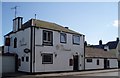
1
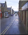
Lower Queen Street in the rain, Carnoustie
Queen Street runs from Carnoustie House Grounds to the crossroads (known as 'The Cross') where it terminates at the High Street. Beyond this is Park Avenue which runs to the railway. At this point there is a pedestrian bridge which can be seen in the photo. Queen Street is mostly residential housing but at this lower point close to the High Street there are a number of shops.
Image: © Gwen and James Anderson
Taken: 20 Jun 2007
0.04 miles
3
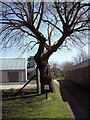
The Dibble Tree
It was in 1797 that Tommas Lauson gave land between the shore and the now High Street to the people of Carnoustie. He stuck a dibble in the ground and reputedly this is the resulting Willow Tree.
Image: © Maigheach-gheal
Taken: 7 Apr 2007
0.05 miles
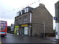
6
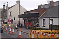
Carnoustie post office
High Street and roadworks.
Image: © Richard Webb
Taken: 12 Mar 2016
0.06 miles
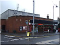
7
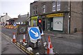
Roadworks, Carnoustie
Temporary lights on Carnoustie High Street.
Image: © Richard Webb
Taken: 12 Mar 2016
0.06 miles
8
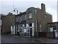
The Nineteenth Hole!!!
On the corner of Kinloch street stands the Nineteenth. The site was once a boat yard with a channel cut to the beach along the route of the adjoining Ferrier Street. It is now a local drinking hole, popular with golfers for an after game drink and the locals. Local bands play live most weekends.
Image: © Gwen and James Anderson
Taken: 9 Jul 2007
0.07 miles
9
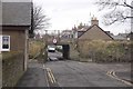
Low bridge, Ferrier Street
A 2.2m clearance bridge in Carnoustie.
Image: © Richard Webb
Taken: 12 Mar 2016
0.07 miles
10
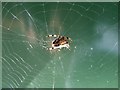
Spider
Busy completing a web close to mid day in late August
Image: © Gwen and James Anderson
Taken: 23 Aug 2008
0.07 miles