IMAGES TAKEN NEAR TO
Maule Street, CARNOUSTIE, DD7 6EU
Introduction
This page details the photographs taken nearby to Maule Street, DD7 6EU by members of the Geograph project.
The Geograph project started in 2005 with the aim of publishing, organising and preserving representative images for every square kilometre of Great Britain, Ireland and the Isle of Man.

There are currently over 7.5m images from over14,400 individuals and you can help contribute to the project by visiting https://www.geograph.org.uk
Image Map
Images are licensed for reuse under creativecommons.org/licenses/by-sa/2.0
Notes
- Clicking on the map will re-center to the selected point.
- The higher the marker number, the further away the image location is from the centre of the postcode.
Image Listing (3 Images Found)
Images are licensed for reuse under creativecommons.org/licenses/by-sa/2.0
Image
Details
Distance
1
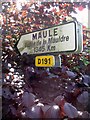
Carnoustie twinned with Maule in France.
Image: © Gwen and James Anderson
Taken: 14 Jun 2007
0.22 miles
2
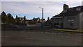
Arbroath Road
At junction with Church Street/Carlogie Road
Image: © Jim Smillie
Taken: 21 Nov 2015
0.23 miles
3
Berryfield allotments, Carnoustie
The relatively new allotments are now packed with vegetable seedlings. However, it is still early in the season and fleece is still in evidence to protect the seedlings from frost.
Berryfield is the first allotment to be established in Carnoustie and the newest in Angus.
Image: © Gwen and James Anderson
Taken: 25 Apr 2009
0.24 miles