IMAGES TAKEN NEAR TO
Linefield Road, CARNOUSTIE, DD7 6DT
Introduction
This page details the photographs taken nearby to Linefield Road, DD7 6DT by members of the Geograph project.
The Geograph project started in 2005 with the aim of publishing, organising and preserving representative images for every square kilometre of Great Britain, Ireland and the Isle of Man.

There are currently over 7.5m images from over14,400 individuals and you can help contribute to the project by visiting https://www.geograph.org.uk
Image Map
Images are licensed for reuse under creativecommons.org/licenses/by-sa/2.0
Notes
- Clicking on the map will re-center to the selected point.
- The higher the marker number, the further away the image location is from the centre of the postcode.
Image Listing (4 Images Found)
Images are licensed for reuse under creativecommons.org/licenses/by-sa/2.0
Image
Details
Distance
1
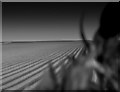
Furrows, Panbride
Furrows sharply picked out by the shadows cast by a low sun. The foreground vegetation of Periwinkle and Ivy covers the fence on the edge of the field.
Image: © Gwen and James Anderson
Taken: 25 Apr 2009
0.18 miles
2
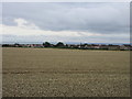
Wheat field at Panbride
Field of wheat at Panbride, with the eastern side of Carnoustie beyond.
Image: © Scott Cormie
Taken: 14 Aug 2018
0.18 miles
3
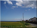
The edge of Carnoustie
At the crossroads just outside Panbride looking towards the North Sea. On the right a modern housing estate, to the left farmland.
Image: © Gwen and James Anderson
Taken: 9 Jul 2007
0.19 miles
4
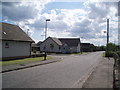
New housing on the outskirts of Carnoustie
The new houses at Panbride view, on the old Panbride road.
Image: © Gwen and James Anderson
Taken: 9 Jul 2007
0.22 miles