IMAGES TAKEN NEAR TO
Panbride Croft, CARNOUSTIE, DD7 6BF
Introduction
This page details the photographs taken nearby to Panbride Croft, DD7 6BF by members of the Geograph project.
The Geograph project started in 2005 with the aim of publishing, organising and preserving representative images for every square kilometre of Great Britain, Ireland and the Isle of Man.

There are currently over 7.5m images from over14,400 individuals and you can help contribute to the project by visiting https://www.geograph.org.uk
Image Map
Images are licensed for reuse under creativecommons.org/licenses/by-sa/2.0
Notes
- Clicking on the map will re-center to the selected point.
- The higher the marker number, the further away the image location is from the centre of the postcode.
Image Listing (11 Images Found)
Images are licensed for reuse under creativecommons.org/licenses/by-sa/2.0
Image
Details
Distance
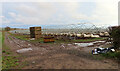
1
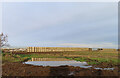
Flooded Farmland
Beyond the flooded corner of the field is a row of tattie (potato) boxes, with polytunnel frames behind them.
Image: © Anne Burgess
Taken: 31 Dec 2023
0.08 miles
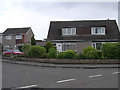
2
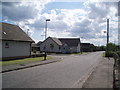
New housing on the outskirts of Carnoustie
The new houses at Panbride view, on the old Panbride road.
Image: © Gwen and James Anderson
Taken: 9 Jul 2007
0.09 miles
3
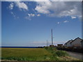
The edge of Carnoustie
At the crossroads just outside Panbride looking towards the North Sea. On the right a modern housing estate, to the left farmland.
Image: © Gwen and James Anderson
Taken: 9 Jul 2007
0.14 miles
4
Field, Panbride
Taken from the Panbride road.
Image: © Gwen and James Anderson
Taken: 9 Jul 2007
0.16 miles
5
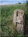
Gate post, Panbride
An old gate post at a field entrance Panbride.
Image: © Gwen and James Anderson
Taken: 9 Jul 2007
0.17 miles
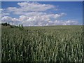
6
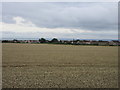
Wheat field at Panbride
Field of wheat at Panbride, with the eastern side of Carnoustie beyond.
Image: © Scott Cormie
Taken: 14 Aug 2018
0.19 miles
7
Dormant Polytunnels
They look pretty scruffy in winter, but will be re-covered in spring for growing strawberries.
Image: © Anne Burgess
Taken: 31 Dec 2023
0.19 miles
8
Modern housing on the outskirts of Carnoustie
This housing was built in the 1970s in the area to the east of the A class road which runs through the square.
Image: © Val Vannet
Taken: 30 May 2005
0.20 miles
9
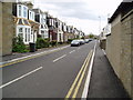
Ireland Street, Carnoustie
View from Station Road showing traditional Scottish housing, built in late 19th/early 20th centuries
Image: © Neil Craven
Taken: 28 Apr 2004
0.20 miles
10
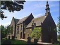
Panbride Kirk
The church in Panbride has a long history. Gifted to Arbroath Abbey by King William the Lion who ruled between 1165 and 1214 and is reputed to have founded the Abbey. The church was dedicated to St. Bride and hence the name of Panbride to the area served by the church. The older part of the church, to the fore in this picture is the burial place of the Maul family whose arms are displayed above the window on the end wall. This part of the church was built in 1681 replacing an earlier structure. The more modern part of the Church built in typically Scottish style, replaced an earlier building in 1851. Just visible on the sunlit wall of the burial aisle are the 'jougs' used to secure unfortunate parishioners in more religiously fundamental times.
Image: © Gwen and James Anderson
Taken: 14 Jun 2007
0.24 miles