IMAGES TAKEN NEAR TO
Fox Street, CARNOUSTIE, DD7 6AJ
Introduction
This page details the photographs taken nearby to Fox Street, DD7 6AJ by members of the Geograph project.
The Geograph project started in 2005 with the aim of publishing, organising and preserving representative images for every square kilometre of Great Britain, Ireland and the Isle of Man.

There are currently over 7.5m images from over14,400 individuals and you can help contribute to the project by visiting https://www.geograph.org.uk
Image Map
Images are licensed for reuse under creativecommons.org/licenses/by-sa/2.0
Notes
- Clicking on the map will re-center to the selected point.
- The higher the marker number, the further away the image location is from the centre of the postcode.
Image Listing (101 Images Found)
Images are licensed for reuse under creativecommons.org/licenses/by-sa/2.0
Image
Details
Distance
1
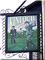
Sign for the Kinloch Arms Hotel
A sign showing the reason for Carnoustie's fame.
Image: © Maigheach-gheal
Taken: 30 Mar 2010
0.02 miles
2
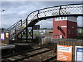
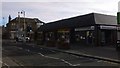
Carnoustie railway station
Through the footbridge there is a glimpse of the beach and the wooded areas of Buddon Ness (MOD land in the distance).
Image: © Val Vannet
Taken: 30 May 2005
0.03 miles
4
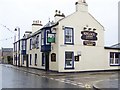
Kinloch Arms Hotel, Carnoustie
The hotel is on the High Street. For a closer view of the sign Image
Image: © Maigheach-gheal
Taken: 30 Mar 2010
0.04 miles
5

Church Street, Carnoustie, circa 1912
Captioned 'Sergs Wives at Carnoustie', referring to the wives of Sergeants from the 3rd Lowland Brigade of the Royal Field Artillery, who were doing their annual training at nearby Barry Buddon in 1912.
Photograph taken by contributor's grandfather, Alexander Wilson Motion (1881-1956), who was himself a Sergeant in the Brigade.
Image: © Alexander Wilson Motion
Taken: Unknown
0.05 miles
6
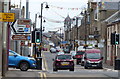
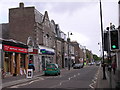
Church Street
Shops beside junction with Station Road
Image: © Jim Smillie
Taken: 21 Nov 2015
0.08 miles
7
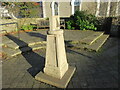
Sundial in Carnoustie
Vertically mounted sundial from 2003, on a plinth in a circular paved area, north of the High Street in Carnoustie.
Image: © Scott Cormie
Taken: 4 Jan 2022
0.09 miles
8
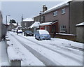
Philip Street, Carnoustie
Looking towards Lochty Street from Green Lane. A number of older buildings exist amongst the victorian and newer residential properties at this end of the street. The former dairy buildings on the north corner of the junction with lochty street is the most notable.
Image: © Gwen and James Anderson
Taken: 12 Feb 2009
0.09 miles
9
Street by the station
Think this should still be Tayside street looking in the Links Parade direction.
Image: © Bill Nicholls
Taken: 28 Jun 2010
0.09 miles