IMAGES TAKEN NEAR TO
Young Court, TAYPORT, DD6 9PL
Introduction
This page details the photographs taken nearby to Young Court, DD6 9PL by members of the Geograph project.
The Geograph project started in 2005 with the aim of publishing, organising and preserving representative images for every square kilometre of Great Britain, Ireland and the Isle of Man.

There are currently over 7.5m images from over14,400 individuals and you can help contribute to the project by visiting https://www.geograph.org.uk
Image Map
Images are licensed for reuse under creativecommons.org/licenses/by-sa/2.0
Notes
- Clicking on the map will re-center to the selected point.
- The higher the marker number, the further away the image location is from the centre of the postcode.
Image Listing (48 Images Found)
Images are licensed for reuse under creativecommons.org/licenses/by-sa/2.0
Image
Details
Distance
1

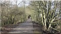
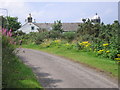
Fife coastal path
The Fife coastal path west of Tayport - very popular with walkers and cyclists
Image: © William Starkey
Taken: 5 Mar 2013
0.07 miles
2
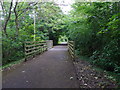
Newport Railway
The railway into Tayport is now used for some of its length by a very popular cycle and footpath. The surrounding woodland was very noisy with birdsong as the winter ages. There were a lot of chaffinches.
Image: © Richard Webb
Taken: 25 Feb 2012
0.09 miles
3
Pathway bridge over Quarry Road
West Common, Tayport; here the Fife Coastal Path crosses over a track between West Lighthouse and a former quarry.
Image: © Stanley Howe
Taken: 25 Jun 2015
0.09 miles
4
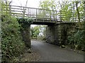
Old railway bridge near Tayport
The bridge is now part of the Fife Coastal Route and passes over Quarry Road.
Image: © Douglas Nelson
Taken: 10 May 2014
0.09 miles
5
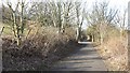
Newport Railway
The railway from Newport to Tayport is now partly used as a cycle path.
Image: © Richard Webb
Taken: 25 Feb 2012
0.11 miles
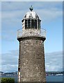
6
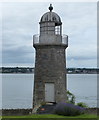
Tayport East Lighthouse
The East Lighthouse was built in 1823 by Robert Stevenson, it is 12 metres (39 feet) in height. It has not been lit since 1848.
Image: © Mat Fascione
Taken: 26 Jun 2017
0.16 miles
7
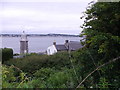
East lighthouse and lighthouse cottage
The view of the East Lighthouse and lighthouse cottage as seen from the road. The Fife Coastal Path Image runs to the south of the road.
Image: © Sandy Gemmill
Taken: 14 Aug 2012
0.16 miles
8
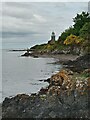
East Lighthouse, Tayport
The picture was taken at highish tide; I think at low tide I could have walked past at least one of the fishermen to get a closer picture from the waterside.
The lighthouse was one of a pair, as its name implies - the West Lighthouse (sometimes called High Light Lighthouse) is still in operation, but the East Lighthouse (sometimes called Low Light Lighthouse) has been out of operation for more than 170 years. This would appear to be due to it being positioned too much in line with its sister lighthouse (I know they're not officially at sea, but assume like boats, lighthouses are all female!) It may be the case that both lighthouses were originally the same height, as the West Lighthouse was extended in height after its original construction - rather unhelpfully this extension is only ever said to have taken place 'in the 19th Century'.
It may not have just been its orientation with respect to the West Lighthouse that led to this lighthouse being let go, as it were. Once decommissioned it was replaced by the Pile Lighthouse, or Tayport Pile, which is basically a wooden lighthouse on stilts sticking out of the estuary. This can be seen towards the right of the water horizon. One of the reasons it was positioned where it is, was to warn sailors that there were dangerously shallow waters on its landward side.
Image: © Ian Dodds
Taken: 9 Jun 2021
0.16 miles
9
East Lighthouse, Tayport
From an old rail track (now Fife Coastal Path).
Image: © Stanley Howe
Taken: 25 Jun 2015
0.16 miles
10
The Eastern Lighthouse, Tayport
This lighthouse dates back to 1823 but has been inactive since 1848.
Image: © Walter Baxter
Taken: 16 Jul 2013
0.16 miles