IMAGES TAKEN NEAR TO
Masons Lane, TAYPORT, DD6 9ER
Introduction
This page details the photographs taken nearby to Masons Lane, DD6 9ER by members of the Geograph project.
The Geograph project started in 2005 with the aim of publishing, organising and preserving representative images for every square kilometre of Great Britain, Ireland and the Isle of Man.

There are currently over 7.5m images from over14,400 individuals and you can help contribute to the project by visiting https://www.geograph.org.uk
Image Map
Images are licensed for reuse under creativecommons.org/licenses/by-sa/2.0
Notes
- Clicking on the map will re-center to the selected point.
- The higher the marker number, the further away the image location is from the centre of the postcode.
Image Listing (142 Images Found)
Images are licensed for reuse under creativecommons.org/licenses/by-sa/2.0
Image
Details
Distance
1
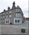
Harbour Cafe, Tayport
On the corner of Tay Street and Castle Street.
Image: © Stanley Howe
Taken: 18 Oct 2017
0.02 miles
2

Harbour Cafe, Tay Street
Tayport. A church run enterprise.
Image: © Stanley Howe
Taken: 25 Jun 2015
0.02 miles
3
Fish and Chip shop, 2 Broad Street
There is a cut bench mark on the corner of the chip shop next to the drain pipe and a closer view can be seen here: Image
Image: © Mark Anderson
Taken: 20 Aug 2021
0.02 miles
4
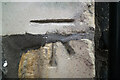
Cut Bench Mark, 2 Broad Street
Bench Mark Database: https://www.bench-marks.org.uk/bm157796
Image: © Mark Anderson
Taken: 20 Aug 2021
0.02 miles
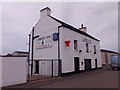
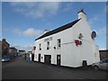
5
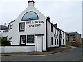
Bell Rock Tavern, Tayport
The Bell Rock Tavern has stood on this spot, on Dalgleish Street, since 1887 and is named after the Bell Rock Lighthouse.
Image: © Maigheach-gheal
Taken: 13 Oct 2010
0.03 miles
6
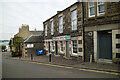
Cobbies Inn, Tay Street
A Tayport pub, backing onto the harbour.
Image: © Stanley Howe
Taken: 25 Jun 2015
0.03 miles
7
Cobbies Inn
Pub on Tay Street, Tayport.
Image: © Oliver Dixon
Taken: 14 Oct 2019
0.03 miles
8
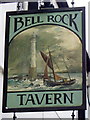
Sign for the Bell Rock Tavern
The tavern is named after a bell which is hung on a dangerous rock, to warn ships away. There was formerly such a bell hung on the Inchcape Reef. For further information on the Bell Rock Lighthouse http://www.nlb.org.uk/LighthouseLibrary/Lighthouse/Bell-Rock/ and for a wider view of the tavern Image and the other side of the sign Image
Image: © Maigheach-gheal
Taken: 13 Oct 2010
0.04 miles
9
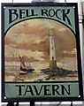
Sign for the Bell Rock Tavern
The tavern is named after a bell which is hung on a dangerous rock, to warn ships away. There was formerly such a bell hung on the Inchcape Reef. For further information on the Bell Rock Lighthouse http://www.nlb.org.uk/LighthouseLibrary/Lighthouse/Bell-Rock/ and for a wider view of the tavern Image and the other side of the sign Image
Image: © Maigheach-gheal
Taken: 13 Oct 2010
0.04 miles
10
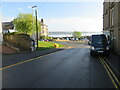
Broad Street descending to the Harbour, Tayport
Looking north-eastward.
Image: © Peter Wood
Taken: 9 May 2021
0.04 miles