IMAGES TAKEN NEAR TO
Inn Street, TAYPORT, DD6 9BL
Introduction
This page details the photographs taken nearby to Inn Street, DD6 9BL by members of the Geograph project.
The Geograph project started in 2005 with the aim of publishing, organising and preserving representative images for every square kilometre of Great Britain, Ireland and the Isle of Man.

There are currently over 7.5m images from over14,400 individuals and you can help contribute to the project by visiting https://www.geograph.org.uk
Image Map
Images are licensed for reuse under creativecommons.org/licenses/by-sa/2.0
Notes
- Clicking on the map will re-center to the selected point.
- The higher the marker number, the further away the image location is from the centre of the postcode.
Image Listing (127 Images Found)
Images are licensed for reuse under creativecommons.org/licenses/by-sa/2.0
Image
Details
Distance
1
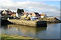
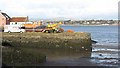
Old Harbour Tayport
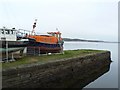
Old harbour and houses to West of the harbour. The old lifeboat is the Duke of Kent.
Image: © Jim Bain
Taken: 13 Feb 2007
0.02 miles
2
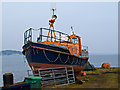
The Duke of Kent
The old lifeboat "Duke of Kent" at Tayport. Built by William Osborne, Littlehampton, 1979; credited with saving more than 80 lives.
Image: © William Starkey
Taken: 5 Mar 2013
0.02 miles
3
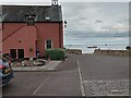
Nos 2 & 3 West Shore, Tayport
West Shore is a modern residential development at the West end of the harbour. It was designed to fit in with the surrounding older architecture, and I have to admit that this building completely fooled me! Due to the presence of the bell-tower I began looking through old maps to find out more about the building, to no avail.
It is a very nice little cul-de-sac, so top marks to the developers.
Image: © Ian Dodds
Taken: 9 Jun 2021
0.02 miles

5
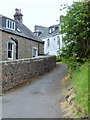
A narrow wynd in Tayport
Between Dalgleish Road and Castle Road.
Image: © Stanley Howe
Taken: 25 Jun 2015
0.04 miles
6
Duke of Kent
A former lifeboat at Tayport, the active lifeboat station is across the water at Broughty Ferry.
Image: © Richard Webb
Taken: 25 Feb 2012
0.04 miles
7
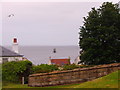
View ENE from Commonty Road, Tayport
Past another stone bridge over a former railway cutting (now in-filled) towards a disused 'Pile Lighthouse' in the River Tay.
Image: © Stanley Howe
Taken: 25 Jun 2015
0.04 miles
8
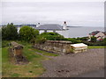
Another stone bridge over former railway cutting (filled-in)
Off Commonty Road, Tayport; with River Tay in background
Image: © Stanley Howe
Taken: 25 Jun 2015
0.04 miles
9
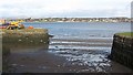
Tayport Harbour
A western section of the harbour which dries out.
Image: © Richard Webb
Taken: 25 Feb 2012
0.04 miles
10
The lifeboat that isn't
This is the former lifeboat 'Duke of Kent' a Rother class RNLI lifeboat built by William Osborne of Littlehampton. It saw service at Eastbourne from 1979 to 1993. After a further year at Eastbourne as a relief boat, she was sold by the RNLI and became a Survey Vessel operating out of Tayport. A lifeboat was stationed at Tayport in 1837, but after the RNLI took over in 1861 activity became centred on the other side of the Firth of Tay at Broughty Ferry, one of the busiest lifeboat stations in Scotland.
Image: © James Allan
Taken: 7 Apr 2014
0.04 miles