IMAGES TAKEN NEAR TO
Tay Street, TAYPORT, DD6 9BH
Introduction
This page details the photographs taken nearby to Tay Street, DD6 9BH by members of the Geograph project.
The Geograph project started in 2005 with the aim of publishing, organising and preserving representative images for every square kilometre of Great Britain, Ireland and the Isle of Man.

There are currently over 7.5m images from over14,400 individuals and you can help contribute to the project by visiting https://www.geograph.org.uk
Image Map
Images are licensed for reuse under creativecommons.org/licenses/by-sa/2.0
Notes
- Clicking on the map will re-center to the selected point.
- The higher the marker number, the further away the image location is from the centre of the postcode.
Image Listing (131 Images Found)
Images are licensed for reuse under creativecommons.org/licenses/by-sa/2.0
Image
Details
Distance
2
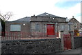
Masonic Lodge, Tayport, Fife
Lodge St Michael No. 246, Tayport, Fife, Scotland.
Image: © Jim Campbell
Taken: 11 Mar 2010
0.01 miles

5

Wallace A Hughes hardware store, 17 Castle Street
From the sign, it looks like electrical and plumbing services are also available.
Image: © Mark Anderson
Taken: 20 Aug 2021
0.06 miles
6
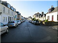
Castle Street in Tayport
Looking south-eastward.
Image: © Peter Wood
Taken: 9 May 2021
0.07 miles
9
'The Auld Hoose'
A former pub; property up for sale, at the junction of Whitenhill and Rose Street in Tayport.
Image: © Stanley Howe
Taken: 25 Jun 2015
0.07 miles
10
Beat of Tayport (Joiners)
William Street, B945
Image: © Stanley Howe
Taken: 25 Jun 2015
0.07 miles