IMAGES TAKEN NEAR TO
Newport Road, TAYPORT, DD6 9AU
Introduction
This page details the photographs taken nearby to Newport Road, DD6 9AU by members of the Geograph project.
The Geograph project started in 2005 with the aim of publishing, organising and preserving representative images for every square kilometre of Great Britain, Ireland and the Isle of Man.

There are currently over 7.5m images from over14,400 individuals and you can help contribute to the project by visiting https://www.geograph.org.uk
Image Map
Images are licensed for reuse under creativecommons.org/licenses/by-sa/2.0
Notes
- Clicking on the map will re-center to the selected point.
- The higher the marker number, the further away the image location is from the centre of the postcode.
Image Listing (44 Images Found)
Images are licensed for reuse under creativecommons.org/licenses/by-sa/2.0
Image
Details
Distance
1
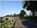
Newport Road (B946)
Beside Ferry Port on Craig Cemetery. Towards Tayport.
Image: © JThomas
Taken: 19 Jul 2021
0.05 miles
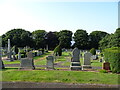
3
Ferryport on Craig Cemetery, Tayport
Looking northward.
Image: © Peter Wood
Taken: 9 May 2021
0.07 miles
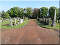
4
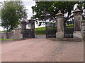
Ferry Port on Craig Cemetery
Main gate; exit to B946.
Image: © Stanley Howe
Taken: 25 Jun 2015
0.07 miles
5
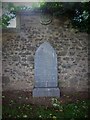
Grave of Admiral William Heriot Maitland-Dougall of Scotscraig
In the family burial ground at Ferry-Port of Craig cemetery. http://www.st-andrews.ac.uk/imu/imu.php?request=display&port=45175&id=f658&flag=start&offset=0&count=10&listcount=10&view=list&sitter=Admiral%20William%20H.%20Maitland%20Dougall&departmentfilter=Special%20Collections&ecatalogue=on
Image: © Stanley Howe
Taken: 25 Jun 2015
0.08 miles
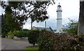
6
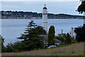
Tayport West Lighthouse
The West Lighthouse (also known as the High Light) was built in 1823 by Robert Stevenson. It is 24 metres (79 feet) in height.
Broughty Ferry is about a mile away across the firth of Tay.
Image: © Mat Fascione
Taken: 26 Jun 2017
0.08 miles
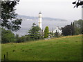
7
West Lighthouse at Tayport
The Fife Coastal Path takes a short diversion at this point.
Image: © Douglas Nelson
Taken: 10 May 2014
0.08 miles
8
West Lighthouse, Tayport
Viewed from The Fife Coastal Path (old railway track).
Image: © Stanley Howe
Taken: 25 Jun 2015
0.08 miles
9
Tayport West Lighthouse
The West Lighthouse (also known as the High Light) was built in 1823 by Robert Stevenson. It is 24 metres (79 feet) in height.
Image: © Mat Fascione
Taken: 26 Jun 2017
0.08 miles
10
Tayport west lighthouse
The view of the west lighthouse Image as seen from the Fife Coastal Path.
Image: © Sandy Gemmill
Taken: 14 Aug 2012
0.08 miles