IMAGES TAKEN NEAR TO
Wormit, NEWPORT-ON-TAY, DD6 8PJ
Introduction
This page details the photographs taken nearby to DD6 8PJ by members of the Geograph project.
The Geograph project started in 2005 with the aim of publishing, organising and preserving representative images for every square kilometre of Great Britain, Ireland and the Isle of Man.

There are currently over 7.5m images from over14,400 individuals and you can help contribute to the project by visiting https://www.geograph.org.uk
Image Map
Images are licensed for reuse under creativecommons.org/licenses/by-sa/2.0
Notes
- Clicking on the map will re-center to the selected point.
- The higher the marker number, the further away the image location is from the centre of the postcode.
Image Listing (8 Images Found)
Images are licensed for reuse under creativecommons.org/licenses/by-sa/2.0
Image
Details
Distance
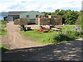
2
Fields of plastic
Between Peacehill and Kilburns farms.
Image: © James Allan
Taken: 28 Apr 2014
0.12 miles
4
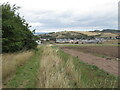
Path around Peacehill
A diversion around the very large farmyard.
Image: © Richard Webb
Taken: 21 Aug 2022
0.20 miles
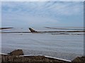
5
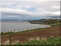
Peace Hill.
Looking over newly sown fields to Wormit and the Tay Bridge
Image: © Richard Webb
Taken: 17 Mar 2005
0.20 miles
6
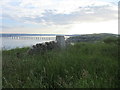
Peace Hill Trig Pillar
The triangulation pillar at Peace Hill, now converted into a memorial and bench. The Firth of Tay and railway bridge are beyond to the north-east.
Image: © Scott Cormie
Taken: 16 Jun 2019
0.22 miles
7
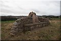
Peacehill trigpoint and bench
For some reason the trigpoint was covered in sackcloth at the time of our visit. It was marked as slightly damaged on the Trigpointing UK website, so perhaps it is undergoing some restorative work?
Image: © Becky Williamson
Taken: 19 Feb 2019
0.23 miles
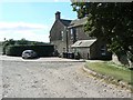
8
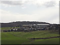
Peacehill Farm from the railway
Home of the abundant potatoes Image
Image: © Ian Paterson
Taken: 23 Mar 2014
0.25 miles