IMAGES TAKEN NEAR TO
Kilmany Road, NEWPORT-ON-TAY, DD6 8PG
Introduction
This page details the photographs taken nearby to Kilmany Road, DD6 8PG by members of the Geograph project.
The Geograph project started in 2005 with the aim of publishing, organising and preserving representative images for every square kilometre of Great Britain, Ireland and the Isle of Man.

There are currently over 7.5m images from over14,400 individuals and you can help contribute to the project by visiting https://www.geograph.org.uk
Image Map
Images are licensed for reuse under creativecommons.org/licenses/by-sa/2.0
Notes
- Clicking on the map will re-center to the selected point.
- The higher the marker number, the further away the image location is from the centre of the postcode.
Image Listing (10 Images Found)
Images are licensed for reuse under creativecommons.org/licenses/by-sa/2.0
Image
Details
Distance
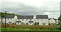
1

A pair of villas on Kilmany Road, Wormit
By B946, entering Wormit from the south. Built on site of former Beehive Timber Works.
Image: © Stanley Howe
Taken: 17 Nov 2015
0.01 miles
2

Road heading in to Wormit in Fife
Passing some truly unique houses on the way.
Image: © James Denham
Taken: 31 May 2010
0.03 miles
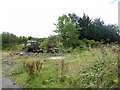
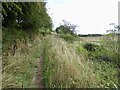
4
Path over Wormit Hill
Mapped as a road, it is actually an enjoyable path.
Image: © Richard Webb
Taken: 21 Aug 2022
0.09 miles
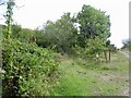
6
Path over Wormit Hill
Mapped as a road, it is actually an enjoyable path.
Image: © Richard Webb
Taken: 21 Aug 2022
0.15 miles

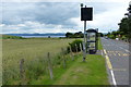
9
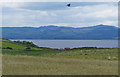
View across Wormit Bay and the Firth of Tay
Image: © Mat Fascione
Taken: 26 Jun 2017
0.21 miles