IMAGES TAKEN NEAR TO
St. Fort Road, NEWPORT-ON-TAY, DD6 8LA
Introduction
This page details the photographs taken nearby to St. Fort Road, DD6 8LA by members of the Geograph project.
The Geograph project started in 2005 with the aim of publishing, organising and preserving representative images for every square kilometre of Great Britain, Ireland and the Isle of Man.

There are currently over 7.5m images from over14,400 individuals and you can help contribute to the project by visiting https://www.geograph.org.uk
Image Map
Images are licensed for reuse under creativecommons.org/licenses/by-sa/2.0
Notes
- Clicking on the map will re-center to the selected point.
- The higher the marker number, the further away the image location is from the centre of the postcode.
Image Listing (28 Images Found)
Images are licensed for reuse under creativecommons.org/licenses/by-sa/2.0
Image
Details
Distance
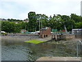
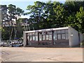
3
Rock House, Woodhaven Harbour
The shoreline between the pier and Rock House (a 3-storey house with slate roof and dormer windows, CANMORE ID 282628) was a mooring place for Catalina Flying Boats during WWII (CANMORE SC 1031197).
Image: © Stanley Howe
Taken: 27 Jun 2016
0.05 miles
4
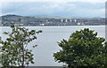
View north across the Firth of Tay
The city of Dundee is two miles away across the Firth.
Image: © Mat Fascione
Taken: 26 Jun 2017
0.05 miles
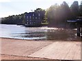
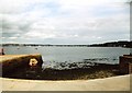
5
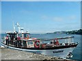
Marigot at Woodhaven pier
This pier was constructed to serve the flying boats that operated from RAF Woodhaven water aerodrome in the Firth of Tay. These included Singapores, Sunderlands, Catalinas and even a captured German Heinkel 115 seaplane which was used for a time to ferry agents from here into German-occupied Norway. Now Woodhaven pier is used by pleasure boats that take tourists up-river as far as Perth or down-river to look for seals, dolphins and whales in the North Sea.
Image: © James Allan
Taken: 14 Aug 2008
0.08 miles
7
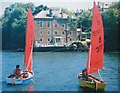
Peaceful times at Woodhaven Pier
Two single-handed Mirror dinghies from Wormit Boating Club http://homepages.rya-online.net/wormit/ taken from Woodhaven (or 'Mars') Pier with the large expanse of Rock House beyond. In the second world war, Catalina flying boats from the Royal Norwegian Air Force were stationed here Image and the race starting box for the club sits atop the remains of the mooring platform.
Even further back, the training ship 'Mars' was stationed off the pier where homeless and destitute boys were 'sent'. http://www.sonsofthemars.com/
Image: © Ian Paterson
Taken: Unknown
0.08 miles
8
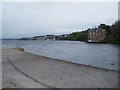
Wormit Boating Club
Woodhaven Harbour.
Image: © Stanley Howe
Taken: 27 Jun 2016
0.10 miles
9
Wormit Harbour
The small pier, also known as Woodhaven Pier, is used predominantly by the Wormit Boating Club. It was formerly a seaplane base.
Image: © Bob Jones
Taken: Unknown
0.11 miles