IMAGES TAKEN NEAR TO
Kirk Road, NEWPORT-ON-TAY, DD6 8JB
Introduction
This page details the photographs taken nearby to Kirk Road, DD6 8JB by members of the Geograph project.
The Geograph project started in 2005 with the aim of publishing, organising and preserving representative images for every square kilometre of Great Britain, Ireland and the Isle of Man.

There are currently over 7.5m images from over14,400 individuals and you can help contribute to the project by visiting https://www.geograph.org.uk
Image Map (Loading...)


Getting Data...Please wait
Leaflet Map data © OpenStreetMap
Images are licensed for reuse under creativecommons.org/licenses/by-sa/2.0
Notes
- Clicking on the map will re-center to the selected point.
- The higher the marker number, the further away the image location is from the centre of the postcode.
Image Listing (16 Images Found)
Images are licensed for reuse under creativecommons.org/licenses/by-sa/2.0
Image
Details
Distance
1
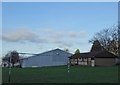
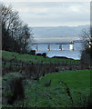
Newport-on-Tay Leisure Centre
The rather muddy, sloping playing fields behind the sports centre in Newport-on-Tay.
Image: © Jackie Proven
Taken: 4 Jan 2015
0.08 miles
2

View of Dundee from Newport-on-Tay
From the Newport-on-Tay playing fields, with the prominent Cox's chimney stack at Camperdown Works across the Tay in Dundee.
Image: © Jackie Proven
Taken: 4 Jan 2015
0.12 miles
3
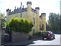
My house is my castle
A wonderful old house in Newport-on-Tay. It appears to be known locally as 'the castle'.
Image: © James Denham
Taken: 31 May 2010
0.12 miles
6
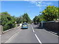
The main road heading in to Newport on Tay town centre
The Tayside town in Fife.
Image: © James Denham
Taken: 31 May 2010
0.15 miles
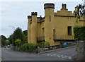
7
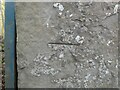
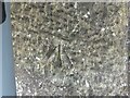
Benchmark on The Castle, Newport on Tay
Ordnance Survey benchmark, described on database at https://www.bench-marks.org.uk/bm143011. See also Image
Image: © Becky Williamson
Taken: 13 Mar 2021
0.15 miles
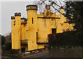
8
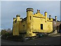
The Castle, Newport on Tay
Early 19th Century Category B Listed Building in Newport on Tay. There is a benchmark on the gatepost just to the left of the street sign. See Image
Image: © Becky Williamson
Taken: 13 Mar 2021
0.15 miles
9
Tay Bridge from Newport-on-Tay
The boundary drainage of Newport-on-Tay playing fields, with Muttonhole woods to the south.
Image: © Jackie Proven
Taken: 4 Jan 2015
0.15 miles
10
Benchmark on Kirk Street/Bridge Street, Newport on Tay
Ordnance Survey benchmark, described on database at https://www.bench-marks.org.uk/bm143012. See also Image
Image: © Becky Williamson
Taken: 13 Mar 2021
0.16 miles