IMAGES TAKEN NEAR TO
Kilnburn, NEWPORT-ON-TAY, DD6 8DE
Introduction
This page details the photographs taken nearby to Kilnburn, DD6 8DE by members of the Geograph project.
The Geograph project started in 2005 with the aim of publishing, organising and preserving representative images for every square kilometre of Great Britain, Ireland and the Isle of Man.

There are currently over 7.5m images from over14,400 individuals and you can help contribute to the project by visiting https://www.geograph.org.uk
Image Map
Images are licensed for reuse under creativecommons.org/licenses/by-sa/2.0
Notes
- Clicking on the map will re-center to the selected point.
- The higher the marker number, the further away the image location is from the centre of the postcode.
Image Listing (107 Images Found)
Images are licensed for reuse under creativecommons.org/licenses/by-sa/2.0
Image
Details
Distance
1

Kilburn, Newport
Kilburn just above its junction with Scott Street with the Tay and Dundee as a backdrop.
Image: © Jim Bain
Taken: 15 May 2007
0.00 miles
2

Kilburn, Newport
The back of Kilburn from near the bowling club.
Image: © Jim Bain
Taken: 15 May 2007
0.01 miles
3
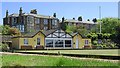
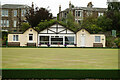
Newport Bowling Club
Newport Bowling Club and greens with houses on the Cupar Road.
Image: © Jim Bain
Taken: 15 May 2007
0.02 miles
4
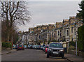
Kilnburn, Newport on Tay
Housing on Kilnburn, Newport on Tay.
Image: © William Starkey
Taken: 4 Mar 2013
0.04 miles
5

Kilburn, Newport
Looking up Kilburn from just below its junction with Scott Street.
Image: © Jim Bain
Taken: 15 May 2007
0.05 miles
7

CoS, Newport
The Church of Scotland on Blyth Street. One of three fine Churches in this small area.
Image: © Jim Bain
Taken: 15 May 2007
0.05 miles
8

Library, Newport
Library buildings from 1890, Scott Street, Newport.
Image: © Jim Bain
Taken: 14 May 2007
0.07 miles
9
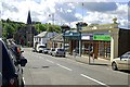
High Street, Newport
Looking west along the short High Street, this is almost all of it, towards the Free Church at the foot of the hill.
Image: © Jim Bain
Taken: 15 May 2007
0.07 miles
10
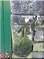
Benchmark on gatepost, Cupar Road, Newport on Tay
Ordnance Survey benchmark, described on database at https://www.bench-marks.org.uk/bm142956.
Image: © Becky Williamson
Taken: 13 Mar 2021
0.08 miles