IMAGES TAKEN NEAR TO
North Bank Street, DUNDEE, DD5 4LN
Introduction
This page details the photographs taken nearby to North Bank Street, DD5 4LN by members of the Geograph project.
The Geograph project started in 2005 with the aim of publishing, organising and preserving representative images for every square kilometre of Great Britain, Ireland and the Isle of Man.

There are currently over 7.5m images from over14,400 individuals and you can help contribute to the project by visiting https://www.geograph.org.uk
Image Map
Images are licensed for reuse under creativecommons.org/licenses/by-sa/2.0
Notes
- Clicking on the map will re-center to the selected point.
- The higher the marker number, the further away the image location is from the centre of the postcode.
Image Listing (13 Images Found)
Images are licensed for reuse under creativecommons.org/licenses/by-sa/2.0
Image
Details
Distance
5
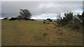
Bench overlooking Monifieth Sands
A wind sculpted tree beside the Firth of Tay.
Image: © Richard Webb
Taken: 23 Feb 2013
0.20 miles
6
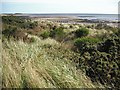
Links, Monifieth
Scrubland on a small strip of dunes between the railway and sea. View over Monifieth Sands towards Buddon Ness.
Image: © Richard Webb
Taken: 7 Sep 2009
0.20 miles
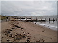
8

Railway line at Monifieth
The East Coast Railway Line heading west from Monifieth towards Broughty Ferry and Dundee.
Image: © Scott Cormie
Taken: 30 Dec 2021
0.22 miles
9
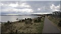
Angus coastal path
Leaving Monifieth for Broughty Ferry.
Image: © Richard Webb
Taken: 23 Feb 2013
0.23 miles
10
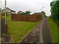
Footpath off West Grange Road, Monifieth
Image: © Alex McGregor
Taken: 7 Jun 2011
0.23 miles