IMAGES TAKEN NEAR TO
The Stables, DUNDEE, DD5 4GB
Introduction
This page details the photographs taken nearby to The Stables, DD5 4GB by members of the Geograph project.
The Geograph project started in 2005 with the aim of publishing, organising and preserving representative images for every square kilometre of Great Britain, Ireland and the Isle of Man.

There are currently over 7.5m images from over14,400 individuals and you can help contribute to the project by visiting https://www.geograph.org.uk
Image Map
Images are licensed for reuse under creativecommons.org/licenses/by-sa/2.0
Notes
- Clicking on the map will re-center to the selected point.
- The higher the marker number, the further away the image location is from the centre of the postcode.
Image Listing (6 Images Found)
Images are licensed for reuse under creativecommons.org/licenses/by-sa/2.0
Image
Details
Distance
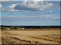
4

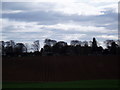
Field north of Monifieth
Looking northwards over a field from Buddon Drive on the northern edge of Monifieth.
Image: © Scott Cormie
Taken: 30 Dec 2021
0.20 miles
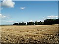
6
Fields near to Ashludie Hospital
Ashludie Hospital can be seen behind the trees at the end of the field.
Image: © Douglas Nelson
Taken: 1 Apr 2012
0.25 miles