IMAGES TAKEN NEAR TO
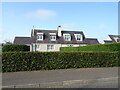
Applehill View, DUNDEE, DD5 3UE
Introduction
This page details the photographs taken nearby to Applehill View, DD5 3UE by members of the Geograph project.
The Geograph project started in 2005 with the aim of publishing, organising and preserving representative images for every square kilometre of Great Britain, Ireland and the Isle of Man.

There are currently over 7.5m images from over14,400 individuals and you can help contribute to the project by visiting https://www.geograph.org.uk
Image Map
Images are licensed for reuse under creativecommons.org/licenses/by-sa/2.0
Notes
- Clicking on the map will re-center to the selected point.
- The higher the marker number, the further away the image location is from the centre of the postcode.
Image Listing (16 Images Found)
Images are licensed for reuse under creativecommons.org/licenses/by-sa/2.0
Image
Details
Distance
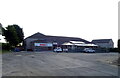
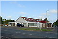
3
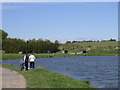
Kingennie Fisheries
A visitor centre with restaurant and shop surrounds the pond which is popular with anglers. It is located in the centre of the grid box.
Image: © Val Vannet
Taken: 15 May 2005
0.20 miles
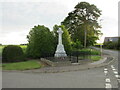
4
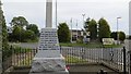
Wellbank war memorial
At a crossroads on the B978.
Image: © Richard Webb
Taken: 16 Jun 2015
0.21 miles
5
Wellbank war memorial at the cross roads
Image: © Elliott Simpson
Taken: 5 Aug 2015
0.21 miles
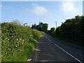
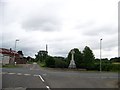
6
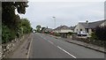
Kellas Road, Wellbank
Between the shop and war memorial.
Image: © Richard Webb
Taken: 16 Jun 2015
0.21 miles
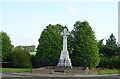
9
Wellbank War Memorial
The grey granite, Celtic cross war memorial on the north side of Wellbank adjacent to the B978.
Image: © Scott Cormie
Taken: 12 Jun 2020
0.22 miles