IMAGES TAKEN NEAR TO
Glasclune Way, DUNDEE, DD5 3TJ
Introduction
This page details the photographs taken nearby to Glasclune Way, DD5 3TJ by members of the Geograph project.
The Geograph project started in 2005 with the aim of publishing, organising and preserving representative images for every square kilometre of Great Britain, Ireland and the Isle of Man.

There are currently over 7.5m images from over14,400 individuals and you can help contribute to the project by visiting https://www.geograph.org.uk
Image Map
Images are licensed for reuse under creativecommons.org/licenses/by-sa/2.0
Notes
- Clicking on the map will re-center to the selected point.
- The higher the marker number, the further away the image location is from the centre of the postcode.
Image Listing (5 Images Found)
Images are licensed for reuse under creativecommons.org/licenses/by-sa/2.0
Image
Details
Distance
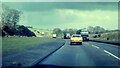
1
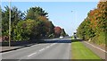
Balgillo Road
A long straight road north of Broughty Ferry.
Image: © Richard Webb
Taken: 27 Sep 2014
0.12 miles
2
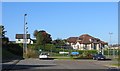
Brougty Ferry Tennis Club
In a recently built extension to Broughty Ferry beside the A92.
Image: © Richard Webb
Taken: 27 Sep 2014
0.12 miles
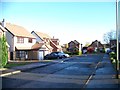
4
Elcho Drive
One of those irritating modern housing developments that is all dead ends, no way out to the path and green strip running along the A92.
Image: © Richard Webb
Taken: 27 Sep 2014
0.18 miles
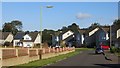
5
The A92 at Balmossie in 1976
This length of road is now a dual carriageway.
Image: © Sandy Gerrard
Taken: Unknown
0.22 miles