IMAGES TAKEN NEAR TO
Newbigging, Broughty Ferry, DUNDEE, DD5 3RG
Introduction
This page details the photographs taken nearby to DD5 3RG by members of the Geograph project.
The Geograph project started in 2005 with the aim of publishing, organising and preserving representative images for every square kilometre of Great Britain, Ireland and the Isle of Man.

There are currently over 7.5m images from over14,400 individuals and you can help contribute to the project by visiting https://www.geograph.org.uk
Image Map
Images are licensed for reuse under creativecommons.org/licenses/by-sa/2.0
Notes
- Clicking on the map will re-center to the selected point.
- The higher the marker number, the further away the image location is from the centre of the postcode.
Image Listing (8 Images Found)
Images are licensed for reuse under creativecommons.org/licenses/by-sa/2.0
Image
Details
Distance
1
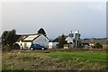
Templehall near The Toll, Newbigging
Image: © Douglas Nelson
Taken: 26 Oct 2012
0.02 miles
2
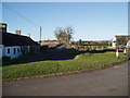
Templehall
A crossroads which judging by names on the map was once a toll bar. The B961 and B962 meet here. For me the important bit was that I got to turn left and away from the very stiff headwind.
Image: © Richard Webb
Taken: 24 Dec 2014
0.03 miles
4

Approaching the end of the B962
The B962 road near its northern end where it becomes the B961.
Image: © Scott Cormie
Taken: 6 May 2018
0.07 miles
5
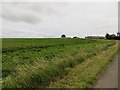
Potato field, Templehall
South of Newbigging.
Image: © Richard Webb
Taken: 15 Aug 2013
0.08 miles
6

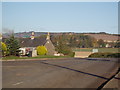
Newbigging
The view is taken from the Drumsturdy road (B961) looking north east to the village of Newbigging.
Image: © Val Vannet
Taken: 15 May 2005
0.15 miles
7
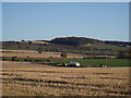
Small Waterworks near Newbigging
The Buddon Burn is hidden from view. It passes through the centreground from west to east before heading south to the sea. The Law near Monikie features in the distance.
Image: © Douglas Nelson
Taken: 26 Oct 2012
0.20 miles
8
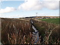
Buddon Burn
Looking towards Newbigging
Image: © Douglas Nelson
Taken: 1 Nov 2012
0.24 miles