IMAGES TAKEN NEAR TO
Drumsturdy Road, DUNDEE, DD5 3RE
Introduction
This page details the photographs taken nearby to Drumsturdy Road, DD5 3RE by members of the Geograph project.
The Geograph project started in 2005 with the aim of publishing, organising and preserving representative images for every square kilometre of Great Britain, Ireland and the Isle of Man.

There are currently over 7.5m images from over14,400 individuals and you can help contribute to the project by visiting https://www.geograph.org.uk
Image Map (Loading...)


Getting Data...Please wait
Leaflet Map data © OpenStreetMap
Images are licensed for reuse under creativecommons.org/licenses/by-sa/2.0
Notes
- Clicking on the map will re-center to the selected point.
- The higher the marker number, the further away the image location is from the centre of the postcode.
Image Listing (4 Images Found)
Images are licensed for reuse under creativecommons.org/licenses/by-sa/2.0
Image
Details
Distance
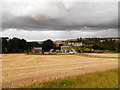
1
West end of Laws Hill
The view is taken from the Drumsturdy road (B961)looking south south west towards Laws Hill.
Image: © Val Vannet
Taken: 15 May 2005
0.06 miles
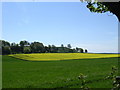
3
Oats, Drumsturdy
This is a huge field, I am unsure as to the identity of the cut crop - it may be the oats, or another crop. There is quite a landscape change here with the igneous Laws Hill having contrasting woodland and parkland on it.
Image: © Richard Webb
Taken: 15 Aug 2013
0.14 miles