IMAGES TAKEN NEAR TO
Monikie, Broughty Ferry, DUNDEE, DD5 3QH
Introduction
This page details the photographs taken nearby to DD5 3QH by members of the Geograph project.
The Geograph project started in 2005 with the aim of publishing, organising and preserving representative images for every square kilometre of Great Britain, Ireland and the Isle of Man.

There are currently over 7.5m images from over14,400 individuals and you can help contribute to the project by visiting https://www.geograph.org.uk
Image Map (Loading...)


Getting Data...Please wait
Leaflet Map data © OpenStreetMap
Images are licensed for reuse under creativecommons.org/licenses/by-sa/2.0
Notes
- Clicking on the map will re-center to the selected point.
- The higher the marker number, the further away the image location is from the centre of the postcode.
Image Listing (7 Images Found)
Images are licensed for reuse under creativecommons.org/licenses/by-sa/2.0
Image
Details
Distance
1
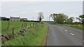
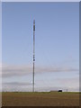
B978, Harecairn
Passing the Forfar transmitter mast.
Image: © Richard Webb
Taken: 16 Jun 2015
0.09 miles
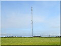
2
Forfar transmitter mast
The transmitter on the Sidlaw Hills southeast of Forfar was a VHF 405 line television mast. Now it provides the FM radio service.
It was built by the BBC to serve Angus and the Firth of Tay area. At the time of construction, 1964, Dundee had reception issues with no local transmitters.
Image: © Richard Webb
Taken: 16 Jun 2015
0.14 miles
3
Forfar Transmitter at Harecairn
The mast at Harecairn viewed from the south on the B978.
Image: © Scott Cormie
Taken: 8 Aug 2017
0.15 miles
4
Forfar Transmitter, Harecairn
Opened on July 13th 1964 to provide the town and the surrounding area with a 405 line service from the BBC. Now only broadcasts BBC FM radio to almost the whole of the north-east of Scotland.
Image: © JThomas
Taken: 20 Jul 2021
0.16 miles
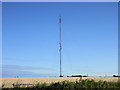
5
Transmitter at Harecairn
The transmitter is viewed from the middle of the grid box on the B978
Image: © Val Vannet
Taken: 31 May 2005
0.19 miles
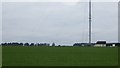
6
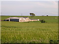
Newlandhead farm
The view is taken looking south east from the middle of the grid square on the B978
Image: © Val Vannet
Taken: 31 May 2005
0.19 miles
7
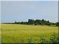
Cereal crop near The Brackens
Off the B978.
Image: © JThomas
Taken: 20 Jul 2021
0.25 miles