IMAGES TAKEN NEAR TO
Monikie, Broughty Ferry, DUNDEE, DD5 3PZ
Introduction
This page details the photographs taken nearby to DD5 3PZ by members of the Geograph project.
The Geograph project started in 2005 with the aim of publishing, organising and preserving representative images for every square kilometre of Great Britain, Ireland and the Isle of Man.

There are currently over 7.5m images from over14,400 individuals and you can help contribute to the project by visiting https://www.geograph.org.uk
Image Map
Images are licensed for reuse under creativecommons.org/licenses/by-sa/2.0
Notes
- Clicking on the map will re-center to the selected point.
- The higher the marker number, the further away the image location is from the centre of the postcode.
Image Listing (9 Images Found)
Images are licensed for reuse under creativecommons.org/licenses/by-sa/2.0
Image
Details
Distance
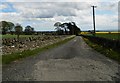
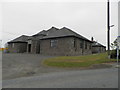
1
Monikie School / Newbigging / Monikie Road Junction
Image: © Alan Morrison
Taken: 29 Dec 2008
0.03 miles
2
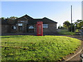
Monikie Telephone Box and Hall
The converted telephone box at Monikie in front of the hall.
Image: © Scott Cormie
Taken: 8 Aug 2017
0.05 miles
5
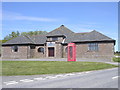
Monikie Village Hall
Monikie village hall commands the junction of the B962 and the minor road which leads into the village. The public phone box is marked on the 1:25000 map!
Image: © Val Vannet
Taken: 15 May 2005
0.16 miles
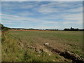
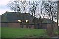
6
Fields Near Monikie Country Park
Fields Near Monikie Country Park
Image: © Mary Rodgers
Taken: 7 Jan 2019
0.19 miles
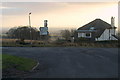
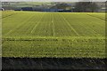
7
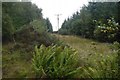
Power line ride
Denfind Plantation, Monikie
Image: © Richard Webb
Taken: 1 Sep 2018
0.19 miles