IMAGES TAKEN NEAR TO
Meadowbank View, DUNDEE, DD5 3PU
Introduction
This page details the photographs taken nearby to Meadowbank View, DD5 3PU by members of the Geograph project.
The Geograph project started in 2005 with the aim of publishing, organising and preserving representative images for every square kilometre of Great Britain, Ireland and the Isle of Man.

There are currently over 7.5m images from over14,400 individuals and you can help contribute to the project by visiting https://www.geograph.org.uk
Image Map (Loading...)


Getting Data...Please wait
Leaflet Map data © OpenStreetMap
Images are licensed for reuse under creativecommons.org/licenses/by-sa/2.0
Notes
- Clicking on the map will re-center to the selected point.
- The higher the marker number, the further away the image location is from the centre of the postcode.
Image Listing (12 Images Found)
Images are licensed for reuse under creativecommons.org/licenses/by-sa/2.0
Image
Details
Distance
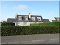
2
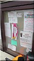
Noticeboard, Wellbank
On the shop wall.
Image: © Richard Webb
Taken: 16 Jun 2015
0.15 miles
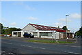
3
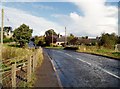
Approach to Wellbank
The Gagie flows under the bridge on the outskirts of Wellbank
Image: © Douglas Nelson
Taken: 3 Oct 2012
0.15 miles
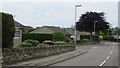
5
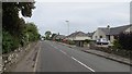
Kellas Road, Wellbank
Between the shop and war memorial.
Image: © Richard Webb
Taken: 16 Jun 2015
0.19 miles
8
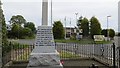
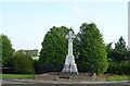
Wellbank war memorial
At a crossroads on the B978.
Image: © Richard Webb
Taken: 16 Jun 2015
0.23 miles
10
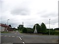
Wellbank war memorial at the cross roads
Image: © Elliott Simpson
Taken: 5 Aug 2015
0.24 miles