IMAGES TAKEN NEAR TO
Kellas, Broughty Ferry, DUNDEE, DD5 3PD
Introduction
This page details the photographs taken nearby to DD5 3PD by members of the Geograph project.
The Geograph project started in 2005 with the aim of publishing, organising and preserving representative images for every square kilometre of Great Britain, Ireland and the Isle of Man.

There are currently over 7.5m images from over14,400 individuals and you can help contribute to the project by visiting https://www.geograph.org.uk
Image Map
Images are licensed for reuse under creativecommons.org/licenses/by-sa/2.0
Notes
- Clicking on the map will re-center to the selected point.
- The higher the marker number, the further away the image location is from the centre of the postcode.
Image Listing (16 Images Found)
Images are licensed for reuse under creativecommons.org/licenses/by-sa/2.0
Image
Details
Distance
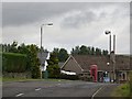
1
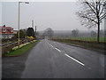
Angus Half Marathon 2010
The B978 through Kellas formed part of the route.
Image: © Douglas Nelson
Taken: 25 Apr 2010
0.06 miles
2
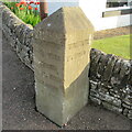
Kellas Milestone
Close up of the Milestone at Kellas.
Image: © Scott Cormie
Taken: 12 Jun 2020
0.08 miles
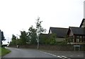
4
Milestone at Kellas
Milestone on the corner of the B978 and Kellas Smiddy road.
Image: © Scott Cormie
Taken: 12 Jun 2020
0.09 miles
5
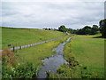
Murroes Burn at Kellas
Flows into the Dighty
Image: © Douglas Nelson
Taken: 19 Jul 2012
0.11 miles
6
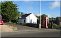
Telephone box, Kellas
One still surviving.
Image: © Richard Webb
Taken: 16 Jun 2015
0.15 miles
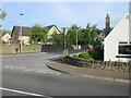
10
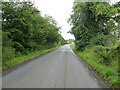
Tree-lined road entering Kellas
Looking south-eastward.
Image: © Peter Wood
Taken: 6 Aug 2021
0.17 miles