IMAGES TAKEN NEAR TO
Newbigging, Broughty Ferry, DUNDEE, DD5 3LA
Introduction
This page details the photographs taken nearby to DD5 3LA by members of the Geograph project.
The Geograph project started in 2005 with the aim of publishing, organising and preserving representative images for every square kilometre of Great Britain, Ireland and the Isle of Man.

There are currently over 7.5m images from over14,400 individuals and you can help contribute to the project by visiting https://www.geograph.org.uk
Image Map (Loading...)


Getting Data...Please wait
Leaflet Map data © OpenStreetMap
Images are licensed for reuse under creativecommons.org/licenses/by-sa/2.0
Notes
- Clicking on the map will re-center to the selected point.
- The higher the marker number, the further away the image location is from the centre of the postcode.
Image Listing (9 Images Found)
Images are licensed for reuse under creativecommons.org/licenses/by-sa/2.0
Image
Details
Distance
1
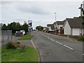
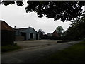
Pitairlie Road, Newbigging
A garage on the left.
Image: © Richard Webb
Taken: 15 Aug 2013
0.03 miles
2
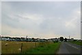
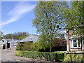
Entering Newbigging Village from Monikie
Image: © Alan Morrison
Taken: 26 Sep 2008
0.06 miles
3
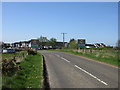
North side of Newbigging
The B961 approaching Newbigging from the north.
Image: © Scott Cormie
Taken: 6 May 2018
0.07 miles
4
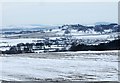
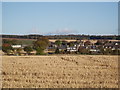
Newbigging village
View of Newbigging in the frozen month of December 2010.
Image: © Kay Williams
Taken: 26 Dec 2010
0.08 miles
5
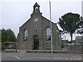
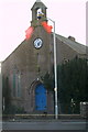
Auld Kirk
Former church at Newbigging now a private residence.
Image: © Russel Wills
Taken: 9 Sep 2015
0.17 miles