IMAGES TAKEN NEAR TO
Calder Crescent, DUNDEE, DD5 3HE
Introduction
This page details the photographs taken nearby to Calder Crescent, DD5 3HE by members of the Geograph project.
The Geograph project started in 2005 with the aim of publishing, organising and preserving representative images for every square kilometre of Great Britain, Ireland and the Isle of Man.

There are currently over 7.5m images from over14,400 individuals and you can help contribute to the project by visiting https://www.geograph.org.uk
Image Map
Images are licensed for reuse under creativecommons.org/licenses/by-sa/2.0
Notes
- Clicking on the map will re-center to the selected point.
- The higher the marker number, the further away the image location is from the centre of the postcode.
Image Listing (8 Images Found)
Images are licensed for reuse under creativecommons.org/licenses/by-sa/2.0
Image
Details
Distance
1
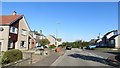
Menteith Street
Suburban Broughty Ferry.
Image: © Richard Webb
Taken: 27 Sep 2014
0.08 miles
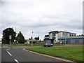
2
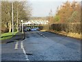
East Balgillo Road
East Balgillo Road heading north towards the roundabout on the A92.
Image: © Scott Cormie
Taken: 2 Jan 2022
0.15 miles
3
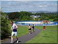
Dundee Half Marathon 2009
The playpark known as Sandy Park was part of the Dundee Half Marathon route in 2009.
Image: © Douglas Nelson
Taken: 21 Jun 2009
0.18 miles
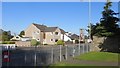
4
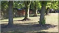
Park, Broughty Ferry
A small park off Forthill Road.
Image: © Richard Webb
Taken: 27 Sep 2014
0.18 miles
5
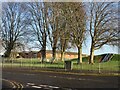
Woodland on the play park
Trees on the play park on Forthill Road, looking from Fintry Place.
Image: © Scott Cormie
Taken: 2 Jan 2022
0.20 miles
8
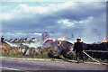
A haystack fire, with Balgillo Park in the background
Image: © Elliott Simpson
Taken: 28 Apr 1967
0.24 miles