IMAGES TAKEN NEAR TO
Ferndale Drive, DUNDEE, DD5 3DA
Introduction
This page details the photographs taken nearby to Ferndale Drive, DD5 3DA by members of the Geograph project.
The Geograph project started in 2005 with the aim of publishing, organising and preserving representative images for every square kilometre of Great Britain, Ireland and the Isle of Man.

There are currently over 7.5m images from over14,400 individuals and you can help contribute to the project by visiting https://www.geograph.org.uk
Image Map
Images are licensed for reuse under creativecommons.org/licenses/by-sa/2.0
Notes
- Clicking on the map will re-center to the selected point.
- The higher the marker number, the further away the image location is from the centre of the postcode.
Image Listing (8 Images Found)
Images are licensed for reuse under creativecommons.org/licenses/by-sa/2.0
Image
Details
Distance
1
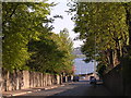
West Ferry, Dundee
High stone walls, mature trees and views to the River Tay are typical of West Ferry
Image: © Val Vannet
Taken: 13 May 2005
0.17 miles
2
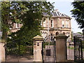
West Ferry 'mansion'
Victorian mansions such as this one are typical of much of West Ferry. They were built during the hey day of the jute industry in Dundee which brought considerable prosperity to the city. History records that in 1900 there were more millionaires living in West Ferry than in any other square mile of the British Empire. Today many of the large houses have been flatted and modern infill building has slightly increased population densities.
Image: © Val Vannet
Taken: 14 May 2005
0.17 miles
3
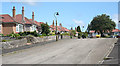
Albert Gardens
Albert Gardens is almost the epitome of quiet suburbia - a development of two dozen matching bungalows in a cul-de-sac off a quiet street. It stands on the site of a typical Broughty Ferry Victorian mansion which was demolished in the mid-20th century. Image] is the view in the opposite direction from the top of the street.
Image: © Anne Burgess
Taken: 29 Jun 2011
0.20 miles
4
Albert Gardens
This is the view in the opposite direction from Image], and I think it is much more attractive in this direction. Albert Gardens is almost the epitome of quiet suburbia - a development of two dozen matching bungalows in a cul-de-sac off a quiet street. It stands on the site of a typical Broughty Ferry Victorian mansion which was demolished in the mid-20th century.
Image: © Anne Burgess
Taken: 29 Jun 2011
0.20 miles
5
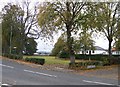
Claypotts Park/Pond from the foot of Duntrune Terrace
Image: © Elliott Simpson
Taken: 16 Oct 2013
0.24 miles
6
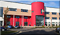
Grove Academy
The main entrance to the new building on Claypotts road is startling, certainly not dull. This was well outside school hours, and the place was busy with comings and goings of adults, presumably using the school sports facilities.
Image: © Anne Burgess
Taken: 29 Jun 2011
0.24 miles
7
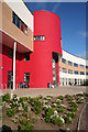
Grove Academy
The main architectural feature of the new buildings is a semicircular tower which in some ways echoes the towers of Claypotts Castle, just up the road. It is a refreshing change from the rectangular grey-white concrete block style of school building which provided so many blots on the urban landscape in the 1960s and 1970s.
Image: © Anne Burgess
Taken: 29 Jun 2011
0.24 miles
8

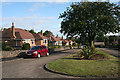
Sweet suburbia
Claypots Road, Broughty Ferry.
Image: © Richard Webb
Taken: 27 Sep 2014
0.25 miles