IMAGES TAKEN NEAR TO
Monifieth Road, DUNDEE, DD5 2SJ
Introduction
This page details the photographs taken nearby to Monifieth Road, DD5 2SJ by members of the Geograph project.
The Geograph project started in 2005 with the aim of publishing, organising and preserving representative images for every square kilometre of Great Britain, Ireland and the Isle of Man.

There are currently over 7.5m images from over14,400 individuals and you can help contribute to the project by visiting https://www.geograph.org.uk
Image Map
Images are licensed for reuse under creativecommons.org/licenses/by-sa/2.0
Notes
- Clicking on the map will re-center to the selected point.
- The higher the marker number, the further away the image location is from the centre of the postcode.
Image Listing (36 Images Found)
Images are licensed for reuse under creativecommons.org/licenses/by-sa/2.0
Image
Details
Distance
1

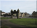
Jubilee Archway
This Victorian arch was erected by James Guthrie Orchar who was one of Dundee's most prominent businessmen, a successful inventor, engineer and entrepreneur. His company was responsible for designing and equipping numerous jute and flax mills in east Scotland, as well as supplying machinery internationally. Today he is remembered primarily as a patron of the arts. His art collection - which contains over 400 paintings, drawings and prints - survives intact and is regarded as one of the most important Victorian collections of Scottish art in the country.
Image: © James Allan
Taken: 8 Mar 2010
0.06 miles
2
Jubilee Arch from the rear
The Queen Victoria Jubilee Arch viewed from the foot of Reres Hill.
Image: © Scott Cormie
Taken: 24 Mar 2017
0.06 miles
3

Jubilee Arch
The Queen Victoria Jubilee Arch at the entrance to Reres Park, viewed from across Monifieth Road.
Image: © Scott Cormie
Taken: 24 Mar 2017
0.06 miles


6
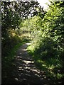
Woodland path
Running up towards the railway from Barnhill Rock Garden.
Image: © Richard Webb
Taken: 7 Sep 2009
0.09 miles
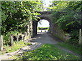
7
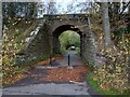
Former railway bridge
Dundee-Forfar line which branched off at Broughty Junction then crossed over Arbroath line
Image: © Jim Smillie
Taken: 29 Oct 2022
0.09 miles
8
Former railway bridge, Broughty Ferry
This bridge once carried the Dundee to Forfar railway line. The line opened in 1870 and was closed completely in 1967.
Image: © Euan Nelson
Taken: 9 May 2015
0.09 miles
9
Former railway bridge, Broughty Ferry Nature Reserve
Image: © PAUL FARMER
Taken: 23 Jul 2015
0.09 miles
10
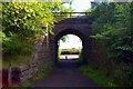
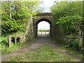
Old railway bridge at Barnhill
A view out to the Firth of Tay through the bridge which formerly carried the branch line from Dundee to Forfar, and is now used for a high-level walkway leading to the Barnhill Rock Garden.
Image: © Tiger
Taken: 21 Aug 2009
0.12 miles