IMAGES TAKEN NEAR TO
Camphill Road, DUNDEE, DD5 2LY
Introduction
This page details the photographs taken nearby to Camphill Road, DD5 2LY by members of the Geograph project.
The Geograph project started in 2005 with the aim of publishing, organising and preserving representative images for every square kilometre of Great Britain, Ireland and the Isle of Man.

There are currently over 7.5m images from over14,400 individuals and you can help contribute to the project by visiting https://www.geograph.org.uk
Image Map
Images are licensed for reuse under creativecommons.org/licenses/by-sa/2.0
Notes
- Clicking on the map will re-center to the selected point.
- The higher the marker number, the further away the image location is from the centre of the postcode.
Image Listing (7 Images Found)
Images are licensed for reuse under creativecommons.org/licenses/by-sa/2.0
Image
Details
Distance
1
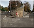
Postbox on corner
A GR postbox between Camphill Road and Bughties Road
Image: © Jim Smillie
Taken: 29 Oct 2022
0.10 miles
3
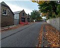
Former stables
On Camphill Road. Possibly served Camphill House
Image: © Jim Smillie
Taken: 29 Oct 2022
0.16 miles
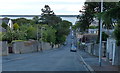
4
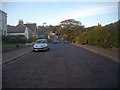
Monifieth Road
Monifieth Road the A930 in Broughty Ferry looking west.
Image: © Scott Cormie
Taken: 24 Mar 2017
0.20 miles
5
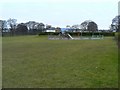
Orchar Park
Children's play area in a Broughty Ferry public park.
Image: © James Allan
Taken: 8 Mar 2010
0.22 miles
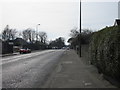
6
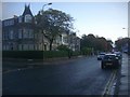
Monifieth Road
The A930 from Dundee to Carnoustie. A good number of small family run B&B type Hotels.
Image: © Bob Embleton
Taken: 30 Oct 2008
0.22 miles
7
Panmure Street, Broughty Ferry
Quite a wide street which once joined the Esplanade on the sea front to the major A930 Monifieth Road. The road is now a quiet cul-de-sac since the railway cut across (behind the camera) allowing only pedestrian access under the bridge. Orchar park is on the right.
Image: © Bob Embleton
Taken: 29 Oct 2008
0.24 miles