IMAGES TAKEN NEAR TO
East Links Place, DUNDEE, DD5 2ES
Introduction
This page details the photographs taken nearby to East Links Place, DD5 2ES by members of the Geograph project.
The Geograph project started in 2005 with the aim of publishing, organising and preserving representative images for every square kilometre of Great Britain, Ireland and the Isle of Man.

There are currently over 7.5m images from over14,400 individuals and you can help contribute to the project by visiting https://www.geograph.org.uk
Image Map (Loading...)


Getting Data...Please wait
Leaflet Map data © OpenStreetMap
Images are licensed for reuse under creativecommons.org/licenses/by-sa/2.0
Notes
- Clicking on the map will re-center to the selected point.
- The higher the marker number, the further away the image location is from the centre of the postcode.
Image Listing (73 Images Found)
Images are licensed for reuse under creativecommons.org/licenses/by-sa/2.0
Image
Details
Distance
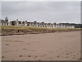
2
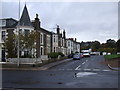
The Esplanade, Broughty Ferry
Speed bump infested residential street along the sea front east of Broughty Ferry. Like many traffic calming measures, the bumps are a complete pain for cyclists. I gave up commuting by bike once because moron planners made the journey too dangerous with lots of supposed road safety gimmicks.
Image: © Richard Webb
Taken: 7 Sep 2009
0.06 miles

4
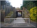
Railway Bridge over Panmure Street, Broughty Ferry
This extremely narrow bridge effectively cuts Panmure Street in two.
Image: © Bob Embleton
Taken: 29 Oct 2008
0.09 miles
5
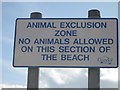
Do the gulls know?
Are there inspectors checking under the logs? NO-tice at Broughty Ferry.
Image: © Richard Webb
Taken: 7 Sep 2009
0.10 miles
6
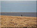
Beach at Broughty Ferry and the Tay Estuary
Image: © Douglas Nelson
Taken: 8 Jan 2013
0.11 miles
8
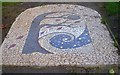
Mosaic, Orchar Park
This apple tree mosaic at the entrance to the park off Panmure Street was created by local volunteers from the Broughty Ferry Environment Project.
Image: © Bob Embleton
Taken: 29 Oct 2008
0.12 miles
9

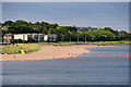
Broughty Ferry Beach
A view of the beach from Broughty Castle
Image: © Paul McIlroy
Taken: 30 Dec 2008
0.13 miles
10
Beach near Broughty Castle
Broughty (Brochtie) Ferry is a suburb of Dundee situated four miles east of the city centre on the north bank of the Firth of Tay. Formerly a prosperous fishing and whaling village, the area was a separate burgh from 1864 until 1913, when it was incorporated into Dundee (https://en.wikipedia.org/wiki/Broughty_Ferry Wikipedia).
Image: © David Dixon
Taken: 8 Jul 2016
0.13 miles