IMAGES TAKEN NEAR TO
Beach Lane, DUNDEE, DD5 1JF

Introduction

This page details the photographs taken nearby to Beach Lane, DD5 1JF by members of the Geograph project.

The Geograph project started in 2005 with the aim of publishing, organising and preserving representative images for every square kilometre of Great Britain, Ireland and the Isle of Man.

There are currently over 7.5m images from over14,400 individuals and you can help contribute to the project by visiting https://www.geograph.org.uk

Image Map


Images are licensed for reuse under creativecommons.org/licenses/by-sa/2.0
Notes
  • Clicking on the map will re-center to the selected point.
  • The higher the marker number, the further away the image location is from the centre of the postcode.

Image Listing (51 Images Found)

Images are licensed for reuse under creativecommons.org/licenses/by-sa/2.0
  • ...
Image
Details
Distance
1
West Ferry
Image: © David Dixon Taken: 8 Jul 2016
0.03 miles
2
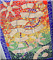
Mosaic at the Grassy Beach, West Ferry
Image: © Gwen and James Anderson Taken: 1 Apr 2009
0.05 miles
3
West Ferry walkway
This walkway is on the path between Dundee and Broughty Ferry.
Image: © william Taken: 15 Jul 2010
0.06 miles
4
The stony beach, looking west towards the grassy beach at West Ferry
Image: © Elliott Simpson Taken: 13 Sep 2008
0.06 miles
5
Eastern end of Grassy Beach Path
The path here is also part of the national cycle network
Image: © Douglas Nelson Taken: 4 Oct 2012
0.06 miles
6
"Bob Servant's Hoose"
The house is one of the locations from the eponymous BBC Four Series Bob Servant Independent.
Image: © Douglas Nelson Taken: 18 Feb 2013
0.06 miles
7
Mosaic on a railway footbridge
At the south access to a pedestrian bridge across a main railway line, this mosaic offers "Remedy for a heavy heart" as the top inscription across the red; "Remedy for a bored dog" is the next; along the yellow beach in the middle we have "Remedy for tired words"; a little lower in the green "Remedy for dragging feet" and at the bottom, reaching into the blue, "Remedy for an old sea".
Image: © James Allan Taken: 21 Feb 2011
0.08 miles
8
Boats on the Firth of Tay
The Tay Road Bridge is visible in the distance.
Image: © Mat Fascione Taken: 25 Jun 2017
0.08 miles
9
Beach, Broughty Ferry
Stone beach to the west of Broughty Ferry.
Image: © Richard Webb Taken: 7 Sep 2009
0.08 miles
10
Beach, Broughty Ferry
The elevated walkway/ cycleway can be seen on the right.
Image: © Dan Taken: 10 Mar 2009
0.08 miles
  • ...