IMAGES TAKEN NEAR TO
West Queen Street, DUNDEE, DD5 1AS
Introduction
This page details the photographs taken nearby to West Queen Street, DD5 1AS by members of the Geograph project.
The Geograph project started in 2005 with the aim of publishing, organising and preserving representative images for every square kilometre of Great Britain, Ireland and the Isle of Man.

There are currently over 7.5m images from over14,400 individuals and you can help contribute to the project by visiting https://www.geograph.org.uk
Image Map
Images are licensed for reuse under creativecommons.org/licenses/by-sa/2.0
Notes
- Clicking on the map will re-center to the selected point.
- The higher the marker number, the further away the image location is from the centre of the postcode.
Image Listing (53 Images Found)
Images are licensed for reuse under creativecommons.org/licenses/by-sa/2.0
Image
Details
Distance
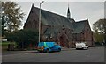
1
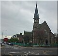
St Luke's and Queen Street, Broughty Ferry
Image: © Douglas Nelson
Taken: 11 Jul 2007
0.03 miles
2

Bowling Green in Albert Road
A beautifully manicured green; the rather stark building in the background is part of the Grove Academy complex.
Image: © Anne Burgess
Taken: 29 Jun 2011
0.04 miles
3
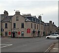
Occidental Bar and Lounge
Corner of Queen Street and Claypotts Road
Image: © Jim Smillie
Taken: 29 Oct 2022
0.05 miles
4
Waiting at the Lights
The lights referred to are at the junction of Queen Street, seen here, and Claypotts Road. The tenements on the right are the ones whose rear view is in Image
Image: © Anne Burgess
Taken: 29 Jun 2011
0.06 miles
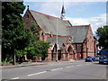
5
St Luke's and Queen Street Church
Building dates from 1884
Image: © Jim Smillie
Taken: 29 Oct 2022
0.06 miles
6
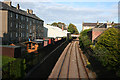
Railway Line at Broughty Ferry
Looking east, towards Carnoustie and Arbroath from the overbridge which carried Westfield Road. On the left are the backs of the tenements on Queen Street, the A930, seen in Image
Image: © Anne Burgess
Taken: 29 Jun 2011
0.10 miles
7
Westfield Road Junction
Front of church just in this square
Image: © Jim Smillie
Taken: 29 Oct 2022
0.11 miles
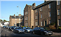
8
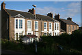
Elmbank House
This is taken from almost the same spot as Image], and provides a complete contrast. These two houses are on the Victorian 25 inch to the mile map, when there were no streets at all west of Claypotts Road. They are now surrounded on the east by the buildings of Grove Academy.
Image: © Anne Burgess
Taken: 29 Jun 2011
0.11 miles
9
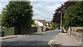
Albert Road
This road is fairly typical of Broughty Ferry, where in the 19th century the prosperous merchants of Dundee built their mansions, surrounded by leafy gardens and usually stone walls to keep out prying eyes, though Albert Road does now have some more modern housing developments. No prizes for guessing whom the street was named after, of course; Prince Albert of Saxe-Coburg-Gotha, consort of Queen Victoria.
Image: © Anne Burgess
Taken: 29 Jun 2011
0.11 miles
10
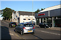
Queen Street
Queen Street is part of what is now the A930, a road built, presumably, to take through traffic out of the centre of Broughty Ferry. It has its share of commercial premises too; this view includes a chartered accountant and a car dealer.
Image: © Anne Burgess
Taken: 29 Jun 2011
0.11 miles