IMAGES TAKEN NEAR TO
Barns Neuk, DUNDEE, DD4 9FH
Introduction
This page details the photographs taken nearby to Barns Neuk, DD4 9FH by members of the Geograph project.
The Geograph project started in 2005 with the aim of publishing, organising and preserving representative images for every square kilometre of Great Britain, Ireland and the Isle of Man.

There are currently over 7.5m images from over14,400 individuals and you can help contribute to the project by visiting https://www.geograph.org.uk
Image Map
Images are licensed for reuse under creativecommons.org/licenses/by-sa/2.0
Notes
- Clicking on the map will re-center to the selected point.
- The higher the marker number, the further away the image location is from the centre of the postcode.
Image Listing (6 Images Found)
Images are licensed for reuse under creativecommons.org/licenses/by-sa/2.0
Image
Details
Distance
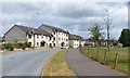
1
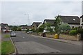
William Fitzgerald Way
A recently built addition to Claverhouse.
Image: © Richard Webb
Taken: 16 Jun 2015
0.06 miles
2
Green space, Barns of Claverhouse
An open space off William Fitzgerald Way on the northern edge of Dundee.
Image: © Richard Webb
Taken: 16 Jun 2015
0.06 miles
3
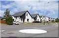
House in William Fitzgerald Way
Barns of Claverhouse in northern Dundee.
Image: © Russel Wills
Taken: 18 Jun 2018
0.07 miles
4
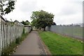
Old road, Claverhouse
A farm road ran here up to Barns of Claverhouse. It is now a path passing modern housing and a school.
Image: © Richard Webb
Taken: 16 Jun 2015
0.07 miles
5
William Fitzgerald Way
Barns of Claverhouse north Dundee.
Image: © Russel Wills
Taken: 18 Jun 2018
0.10 miles
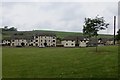
6
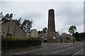
Select Fireplace Company Ltd
Select alright, look at the size of the chimney. Industrial remnant at Claverhouse.
Image: © Richard Webb
Taken: 16 Jun 2015
0.22 miles