IMAGES TAKEN NEAR TO
Mains Drive, DUNDEE, DD4 9BW
Introduction
This page details the photographs taken nearby to Mains Drive, DD4 9BW by members of the Geograph project.
The Geograph project started in 2005 with the aim of publishing, organising and preserving representative images for every square kilometre of Great Britain, Ireland and the Isle of Man.

There are currently over 7.5m images from over14,400 individuals and you can help contribute to the project by visiting https://www.geograph.org.uk
Image Map
Images are licensed for reuse under creativecommons.org/licenses/by-sa/2.0
Notes
- Clicking on the map will re-center to the selected point.
- The higher the marker number, the further away the image location is from the centre of the postcode.
Image Listing (4 Images Found)
Images are licensed for reuse under creativecommons.org/licenses/by-sa/2.0
Image
Details
Distance
1
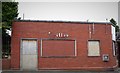
Keiller's Factory
Keiller's marmalade was famous all over the world. The factory made preserves and sweets. Sadly after almost 200 years the factory closed. https://canmore.org.uk/site/82871/dundee-mains-loan-keiller-factory
Image: © Mary Rodgers
Taken: 5 Apr 2017
0.10 miles
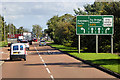
4
Junction of Forfar Road with the Dundee Bypass
Image: © Stanley Howe
Taken: 24 May 2009
0.24 miles