IMAGES TAKEN NEAR TO
Balunie Avenue, DUNDEE, DD4 8TP
Introduction
This page details the photographs taken nearby to Balunie Avenue, DD4 8TP by members of the Geograph project.
The Geograph project started in 2005 with the aim of publishing, organising and preserving representative images for every square kilometre of Great Britain, Ireland and the Isle of Man.

There are currently over 7.5m images from over14,400 individuals and you can help contribute to the project by visiting https://www.geograph.org.uk
Image Map
Images are licensed for reuse under creativecommons.org/licenses/by-sa/2.0
Notes
- Clicking on the map will re-center to the selected point.
- The higher the marker number, the further away the image location is from the centre of the postcode.
Image Listing (3 Images Found)
Images are licensed for reuse under creativecommons.org/licenses/by-sa/2.0
Image
Details
Distance
1
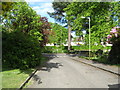
Road junction at Claypotts Road in Dundee
Near Claypotts Castle.
Image: © James Denham
Taken: 2 Jun 2010
0.23 miles
2
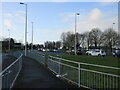
Claypotts Junction
The busy Claypotts Junction at the intersection of the A92 with the B978.
Image: © Scott Cormie
Taken: 2 Jan 2022
0.24 miles
3
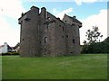
Claypotts Castle
Claypotts Castle was built between 1569 and 1588. In 1601, ownership passed to Sir William Graham of Balunie, and in 1620 the castle was purchased by Sir William Graham of Claverhouse, great-grandfather of John Graham of Claverhouse. Following Claverhouse's defeat and death at the battle of Killiekrankie in 1689, Claypotts Castle was forfeited and granted to the Marquis of Douglas in 1694. The castle is now under the care of Historic Scotland, but unfortunately is not a staffed property.
Image: © Euan Nelson
Taken: 17 Jul 2011
0.24 miles