IMAGES TAKEN NEAR TO
Kingsway East, DUNDEE, DD4 8SL
Introduction
This page details the photographs taken nearby to Kingsway East, DD4 8SL by members of the Geograph project.
The Geograph project started in 2005 with the aim of publishing, organising and preserving representative images for every square kilometre of Great Britain, Ireland and the Isle of Man.

There are currently over 7.5m images from over14,400 individuals and you can help contribute to the project by visiting https://www.geograph.org.uk
Image Map
Images are licensed for reuse under creativecommons.org/licenses/by-sa/2.0
Notes
- Clicking on the map will re-center to the selected point.
- The higher the marker number, the further away the image location is from the centre of the postcode.
Image Listing (9 Images Found)
Images are licensed for reuse under creativecommons.org/licenses/by-sa/2.0
Image
Details
Distance
1
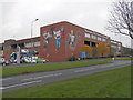
D C Thomson & Co Ltd printing works
Denis the Menace, Desperate Dan and Oor Wullie share the same "page" on the mural.
Image: © Douglas Nelson
Taken: 26 Nov 2014
0.01 miles
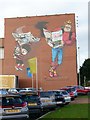
2
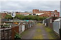
Mid Craigie Road, Dundee
Off A972(Kingsway East); mural paintings of 'comic-cuts' characters on the wall of DC Thompson's colour printing works.
Image: © Stanley Howe
Taken: 2 Apr 2015
0.05 miles
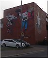
3
Mural on the east wall of DC Thomson's Kingsway Print Plant
Dennis the Menace and Desperate Dan, two of the famous characters from the company's Beano and Dandy comics.
Image: © Graham Hogg
Taken: 7 Nov 2016
0.05 miles
5
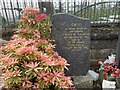
Family Grave
The grave of Eirlys Greig (Thomas) and John Greig
Grandparents of the photographer Ralph Greig
Image: © Ralph Greig
Taken: 17 May 2023
0.14 miles
6
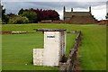
Graigie Park
The home dugout at Craigie Park, home ground to East Craigie Football Club.
Image: © Paul McIlroy
Taken: 12 Jul 2008
0.21 miles
8
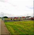
Allotments
Allotments at Old Craigie Road, the large building in the picture is the Kingsway East plant of DC Thomson
Image: © Paul McIlroy
Taken: 12 Jul 2008
0.21 miles
9
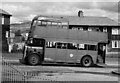
Old "Treelopper" climbs Pitkerro Road
Taken at the junction of Kingennie Terrace (now redeveloped and renamed).
This old bus was used for training purposes and its butchered top allowed Transport staff to lop tree branches overhanging the bus routes.
On the horizon, just in front of the bus's upper deck front window can be seen a snow covered Craigowl - highest peak of the Sidlaws range at 455 metres - about 9 kilometres to the northwest
Image: © Iain Farquhar
Taken: Unknown
0.24 miles