IMAGES TAKEN NEAR TO
Birks Terrace, DUNDEE, DD4 8EJ
Introduction
This page details the photographs taken nearby to Birks Terrace, DD4 8EJ by members of the Geograph project.
The Geograph project started in 2005 with the aim of publishing, organising and preserving representative images for every square kilometre of Great Britain, Ireland and the Isle of Man.

There are currently over 7.5m images from over14,400 individuals and you can help contribute to the project by visiting https://www.geograph.org.uk
Image Map
Images are licensed for reuse under creativecommons.org/licenses/by-sa/2.0
Notes
- Clicking on the map will re-center to the selected point.
- The higher the marker number, the further away the image location is from the centre of the postcode.
Image Listing (11 Images Found)
Images are licensed for reuse under creativecommons.org/licenses/by-sa/2.0
Image
Details
Distance
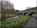
3
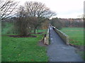
Aqueduct now used as cycle and footpath
This former aqueduct once carried Dundee's water supply from Monikie reservoir.
Image: © Douglas Nelson
Taken: 22 Nov 2014
0.19 miles
4
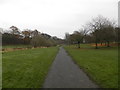
Foot and cycle path in Finlathen Park, Dundee
Image: © Douglas Nelson
Taken: 26 Nov 2014
0.20 miles
5
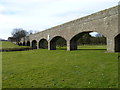
Finlathen aqueduct
This bridge was erected by the Dundee Water Company between 1846 and 1847 to carry a water pipeline from the Monikie reservoir across the Dighty valley to Dundee. An expensive undertaking but probably cheaper than tunnelling under the Dighty burn. The aqueduct was once covered with turf to prevent the water freezing in winter and to keep it cool in the summer. The bridge now serves as a foot and cycle path for Fintry residents. And it still carries two 10-inch water pipes. The blue plaque in the centre is a mosaic carrying the legend ‘Spirit of the Dighty’.
Image: © James Allan
Taken: 21 Mar 2016
0.22 miles
6
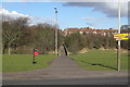
View of Footbridge over Dighty Water, leading to Fintry
Picture taken from Fountainbleau Drive, Dundee, at its junction with Pitkerro Drive.
Image: © Alan Morrison
Taken: 1 Mar 2009
0.22 miles
7
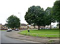
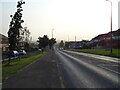
Pikerro Road from Fountainbleau Drive
Image: © Elliott Simpson
Taken: 4 Aug 2015
0.22 miles
8
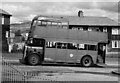
Old "Treelopper" climbs Pitkerro Road
Taken at the junction of Kingennie Terrace (now redeveloped and renamed).
This old bus was used for training purposes and its butchered top allowed Transport staff to lop tree branches overhanging the bus routes.
On the horizon, just in front of the bus's upper deck front window can be seen a snow covered Craigowl - highest peak of the Sidlaws range at 455 metres - about 9 kilometres to the northwest
Image: © Iain Farquhar
Taken: Unknown
0.23 miles
9
The Dighty in Finlathen Park
The Dighty flows under an aqueduct now used as a foot and cycle path.
Image: © Douglas Nelson
Taken: 26 Nov 2014
0.24 miles
10
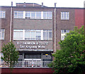
Desperate Dan lives here!
These are the colour printing works of D.C. Thomson located on the Kingsway, Dundee, where weekly comics and magazines are printed and despatched from. Dundee was once a city of 3 'J's - jute, jam and journalism. Today, of the big three, only journalism survives.
Image: © Val Vannet
Taken: 28 May 2004
0.24 miles