IMAGES TAKEN NEAR TO
Honeygreen Road, DUNDEE, DD4 8BQ
Introduction
This page details the photographs taken nearby to Honeygreen Road, DD4 8BQ by members of the Geograph project.
The Geograph project started in 2005 with the aim of publishing, organising and preserving representative images for every square kilometre of Great Britain, Ireland and the Isle of Man.

There are currently over 7.5m images from over14,400 individuals and you can help contribute to the project by visiting https://www.geograph.org.uk
Image Map (Loading...)


Getting Data...Please wait
Leaflet Map data © OpenStreetMap
Images are licensed for reuse under creativecommons.org/licenses/by-sa/2.0
Notes
- Clicking on the map will re-center to the selected point.
- The higher the marker number, the further away the image location is from the centre of the postcode.
Image Listing (22 Images Found)
Images are licensed for reuse under creativecommons.org/licenses/by-sa/2.0
Image
Details
Distance
1
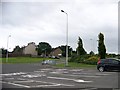
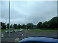
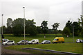
Junction of Fintry Road and Fountainbleau Drive
Image: © Elliott Simpson
Taken: 4 Aug 2015
0.06 miles
3
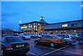
Morrisons on Afton Way, Dundee
Seen from A90 dual carriageway.
Image: © Stanley Howe
Taken: 9 Apr 2015
0.08 miles
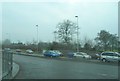
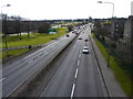
5
Junction of A90 with Claverhouse Road, Dundee
Traffic light controlled junction.
Image: © Stanley Howe
Taken: 28 May 2016
0.10 miles
6
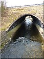
Drowning in the Dighty
An abandoned supermarket trolley, half submerged in the Dighty Water near Fintry, Dundee.
Image: © James Allan
Taken: 21 Mar 2016
0.12 miles
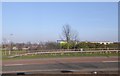
9
Claverhouse Road, Dundee
At the junction with the A90, here named Forfar Road.
Image: © Mike Pennington
Taken: 10 Jun 2013
0.14 miles
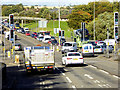
10
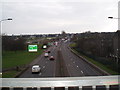
A90 approaching Dundee
The junction of A90 with Claverhouse Road.
Image: © James Allan
Taken: 21 Mar 2016
0.15 miles