IMAGES TAKEN NEAR TO
Craigie Drive, DUNDEE, DD4 7PE
Introduction
This page details the photographs taken nearby to Craigie Drive, DD4 7PE by members of the Geograph project.
The Geograph project started in 2005 with the aim of publishing, organising and preserving representative images for every square kilometre of Great Britain, Ireland and the Isle of Man.

There are currently over 7.5m images from over14,400 individuals and you can help contribute to the project by visiting https://www.geograph.org.uk
Image Map
Images are licensed for reuse under creativecommons.org/licenses/by-sa/2.0
Notes
- Clicking on the map will re-center to the selected point.
- The higher the marker number, the further away the image location is from the centre of the postcode.
Image Listing (28 Images Found)
Images are licensed for reuse under creativecommons.org/licenses/by-sa/2.0
Image
Details
Distance
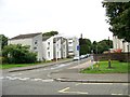
1

Craigie Drive
Saw toothed houses between Dundee and Broughty Ferry.
Image: © Richard Webb
Taken: 27 Sep 2014
0.03 miles
2
Old signage
A sign that lasted for more than four minutes. A relic from the Cold War with Royal Observer Corps and Civil Defence. Modern fans of weapons of mass destruction have left their mark too.
Image: © Richard Webb
Taken: 27 Sep 2014
0.09 miles
4
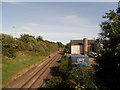
Dundee to Aberdeen East Coast line at Stannergate, Dundee
Image: © Douglas Nelson
Taken: 29 Aug 2016
0.14 miles
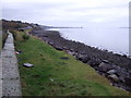
7
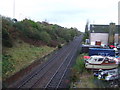
Railway heading east
East Coast Main Line towards Arbroath.
Image: © JThomas
Taken: 23 Oct 2013
0.18 miles