IMAGES TAKEN NEAR TO
East Haddon Road, DUNDEE, DD4 7LB
Introduction
This page details the photographs taken nearby to East Haddon Road, DD4 7LB by members of the Geograph project.
The Geograph project started in 2005 with the aim of publishing, organising and preserving representative images for every square kilometre of Great Britain, Ireland and the Isle of Man.

There are currently over 7.5m images from over14,400 individuals and you can help contribute to the project by visiting https://www.geograph.org.uk
Image Map (Loading...)


Getting Data...Please wait
Leaflet Map data © OpenStreetMap
Images are licensed for reuse under creativecommons.org/licenses/by-sa/2.0
Notes
- Clicking on the map will re-center to the selected point.
- The higher the marker number, the further away the image location is from the centre of the postcode.
Image Listing (46 Images Found)
Images are licensed for reuse under creativecommons.org/licenses/by-sa/2.0
Image
Details
Distance
1

Broughton Ferry Road in Dundee
At the junction of Dalgleish Road.
Image: © Mat Fascione
Taken: 25 Jun 2017
0.11 miles
2
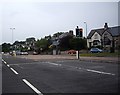
Junction of Broughty Ferry Road (A930) with the A92
Traffic light controlled junction, to the east of Dundee.
Image: © Stanley Howe
Taken: 20 Aug 2013
0.13 miles
3
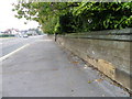
Arbroath Road, Dundee
The wall is that of the large cemetery and is beside the B959.
Image: © Maigheach-gheal
Taken: 10 Oct 2010
0.15 miles
4

Train from Aberdeen
Train arriving in Dundee from Aberdeen, passing Dundee docks.
Image: © Richard Webb
Taken: 7 Sep 2009
0.15 miles
5
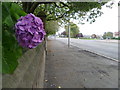
Arbroath Road, Dundee
The B959, Arbroath Road passes the cemetery.
Image: © Maigheach-gheal
Taken: 10 Oct 2010
0.16 miles
6
Cemetery wall, Arbroath Road
There is an Ordnance Survey bench mark on the pillar.
Image: © Maigheach-gheal
Taken: 10 Oct 2010
0.16 miles
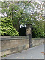
7
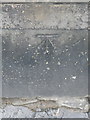
Bench Mark, Arbroath Road
The bench mark is to be found on the cemetery wall. The cemetery is beside the B959, Arbroath Road. For a photograph of the wall Image and for further information on the cut mark http://www.bench-marks.org.uk/bm36126
Image: © Maigheach-gheal
Taken: 10 Oct 2010
0.16 miles
8
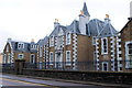
Carolina Court
I lived here from 1967 to 1973 when it was a children's home called Carolina House.
Image: © william
Taken: 15 Jul 2010
0.16 miles
9
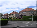
Craigiebank, Dundee
Local Authority housing from the inter war period which has largely gone out of public ownership as a result of tenants' right-to-buy legislation.
Image: © Val Vannet
Taken: 7 May 2005
0.16 miles
10

Tay Cafe
A closed cafe, Dundee Docks. The railway to Aberdeen on the left.
Image: © Richard Webb
Taken: 7 Sep 2009
0.16 miles