IMAGES TAKEN NEAR TO
Loraine Road, DUNDEE, DD4 7DZ
Introduction
This page details the photographs taken nearby to Loraine Road, DD4 7DZ by members of the Geograph project.
The Geograph project started in 2005 with the aim of publishing, organising and preserving representative images for every square kilometre of Great Britain, Ireland and the Isle of Man.

There are currently over 7.5m images from over14,400 individuals and you can help contribute to the project by visiting https://www.geograph.org.uk
Image Map (Loading...)


Getting Data...Please wait
Leaflet Map data © OpenStreetMap
Images are licensed for reuse under creativecommons.org/licenses/by-sa/2.0
Notes
- Clicking on the map will re-center to the selected point.
- The higher the marker number, the further away the image location is from the centre of the postcode.
Image Listing (16 Images Found)
Images are licensed for reuse under creativecommons.org/licenses/by-sa/2.0
Image
Details
Distance
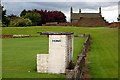
1
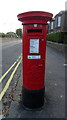
George VI postbox on Pitkerro Road, Dundee
Postbox No. DD4 161.
Image: © JThomas
Taken: 20 Jul 2021
0.09 miles
3
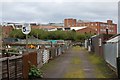
Stobsmuir park
The two ponds (boating and Swannie)
Image: © Freethinker
Taken: 31 Jan 2009
0.11 miles
4
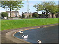
Swanny Ponds
We used to hire rowing boats here.Its proper name is Stobsmuir Park.
Image: © william
Taken: 6 Sep 2011
0.12 miles
5
Allotments
Allotments at Old Craigie Road, the large building in the picture is the Kingsway East plant of DC Thomson
Image: © Paul McIlroy
Taken: 12 Jul 2008
0.16 miles
6
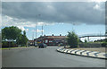
Entering a roundabout in north Dundee
Photographer is above the paved surface on a light traffic late morning
Image: © C Michael Hogan
Taken: 10 Jun 2011
0.20 miles
7
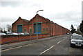
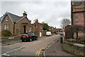
Tram sheds
The old tram sheds at the Maryfield depot
Image: © Freethinker
Taken: 8 Mar 2009
0.21 miles
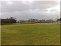
8
Graigie Park
The home dugout at Craigie Park, home ground to East Craigie Football Club.
Image: © Paul McIlroy
Taken: 12 Jul 2008
0.21 miles
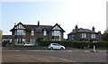
10
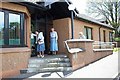
Priory Court, Dundee
Servite Sheltered Housing
Image: © Elliott Simpson
Taken: 12 Jul 2003
0.22 miles