IMAGES TAKEN NEAR TO
Tealing, DUNDEE, DD4 0RD
Introduction
This page details the photographs taken nearby to DD4 0RD by members of the Geograph project.
The Geograph project started in 2005 with the aim of publishing, organising and preserving representative images for every square kilometre of Great Britain, Ireland and the Isle of Man.

There are currently over 7.5m images from over14,400 individuals and you can help contribute to the project by visiting https://www.geograph.org.uk
Image Map (Loading...)


Getting Data...Please wait
Leaflet Map data © OpenStreetMap
Images are licensed for reuse under creativecommons.org/licenses/by-sa/2.0
Notes
- Clicking on the map will re-center to the selected point.
- The higher the marker number, the further away the image location is from the centre of the postcode.
Image Listing (15 Images Found)
Images are licensed for reuse under creativecommons.org/licenses/by-sa/2.0
Image
Details
Distance
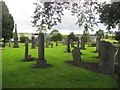
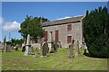
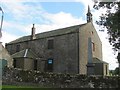
2
Church, Kirkton of Tealing
This church is no longer in use as services are now held in Murroes church.
Image: © Dan
Taken: 19 Dec 2009
0.02 miles
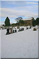
3
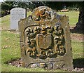
Gravestone
An elaborately carved old gravestone in Tealing Kirkyard. The inscription on the other side names John Walker and the date 1795.
Image: © Anne Burgess
Taken: 15 Aug 2010
0.03 miles
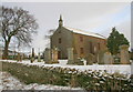
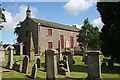
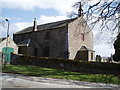
4
Tealing Parish Kirk
The parish kirk of Tealing dates from 1806, with aletrations in 1895 by Alexander Johnston. It is a Category A listed building. No longer in use as a kirk since the parish was amalgamated with Murroes, it was handed over to a heritage group in 1986. Full details at http://hsewsf.sedsh.gov.uk/hslive/hsstart?P_HBNUM=17450
Image: © Anne Burgess
Taken: 15 Aug 2010
0.03 miles
5
Tealing Parish Kirk
The parish kirk of Tealing dates from 1806, with aletrations in 1895 by Alexander Johnston. It is a Category A listed building. No longer in use as a kirk since the parish was amalgamated with Murroes, it was handed over to a heritage group in 1986. Full details at http://hsewsf.sedsh.gov.uk/hslive/hsstart?P_HBNUM=17450
Image: © Anne Burgess
Taken: 15 Aug 2010
0.03 miles
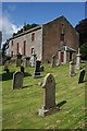
6
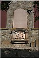
Scrimgeour Tomb
This impressive monument on the south wall of Tealing Parish Kirk is the memorial to the Scrymsoure or Scrimgeour family of Tealing.
Image: © Anne Burgess
Taken: 15 Aug 2010
0.03 miles
8
Tealing Parish Kirk
The parish kirk of Tealing dates from 1806, with aletrations in 1895 by Alexander Johnston. It is a Category A listed building. No longer in use as a kirk since the parish was amalgamated with Murroes, it was handed over to a heritage group in 1986. Full details at http://hsewsf.sedsh.gov.uk/hslive/hsstart?P_HBNUM=17450
Image: © Anne Burgess
Taken: 15 Aug 2010
0.04 miles
9
Tealing Kirk
No longer in use following a parish amalgamation, the building is for sale and has a big hole in the roof.
Image: © Richard Webb
Taken: 23 Jul 2015
0.04 miles
10
Tealing Parish Church
Now disused, the church was the centre of the small hamlet of Kirkton of Tealing.
Image: © Douglas Nelson
Taken: 22 Apr 2013
0.04 miles