IMAGES TAKEN NEAR TO
DUNDEE, DD4 0QE
Introduction
This page details the photographs taken nearby to DD4 0QE by members of the Geograph project.
The Geograph project started in 2005 with the aim of publishing, organising and preserving representative images for every square kilometre of Great Britain, Ireland and the Isle of Man.

There are currently over 7.5m images from over14,400 individuals and you can help contribute to the project by visiting https://www.geograph.org.uk
Image Map
Images are licensed for reuse under creativecommons.org/licenses/by-sa/2.0
Notes
- Clicking on the map will re-center to the selected point.
- The higher the marker number, the further away the image location is from the centre of the postcode.
Image Listing (4 Images Found)
Images are licensed for reuse under creativecommons.org/licenses/by-sa/2.0
Image
Details
Distance
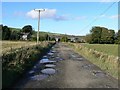
2
Over Finlarg Farm
This farm is situated to the North of the road to Glamis. The farm is at the end of a private road and I thought it prudent not to get too close. The photo was taken from the end of the farm road.
Image: © Christopher Gillan
Taken: 10 Oct 2006
0.04 miles
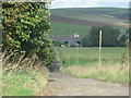
3
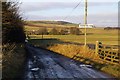
Over Finlarg Farm, Angus, near Lumley Den
The farm road end is about 1 mile north west of the Dundee / Forfar Road (A90 dual carriageway)
Image: © Alan Morrison
Taken: 6 Jan 2008
0.04 miles
4
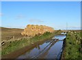
Damp straw?
A stack of unprotected straw bales alongside a flooded farm track.
Image: © James Allan
Taken: 13 Oct 2008
0.20 miles