IMAGES TAKEN NEAR TO
Old Glamis Road, DUNDEE, DD3 8JA
Introduction
This page details the photographs taken nearby to Old Glamis Road, DD3 8JA by members of the Geograph project.
The Geograph project started in 2005 with the aim of publishing, organising and preserving representative images for every square kilometre of Great Britain, Ireland and the Isle of Man.

There are currently over 7.5m images from over14,400 individuals and you can help contribute to the project by visiting https://www.geograph.org.uk
Image Map (Loading...)


Getting Data...Please wait
Leaflet Map data © OpenStreetMap
Images are licensed for reuse under creativecommons.org/licenses/by-sa/2.0
Notes
- Clicking on the map will re-center to the selected point.
- The higher the marker number, the further away the image location is from the centre of the postcode.
Image Listing (9 Images Found)
Images are licensed for reuse under creativecommons.org/licenses/by-sa/2.0
Image
Details
Distance
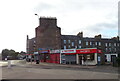
1

SNP Dundee Parliamentary Office
On Old Glamis Road.
Image: © JThomas
Taken: 11 Jun 2021
0.05 miles

4
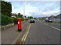
Park Road, Dundee
Showing position of Postbox No. DD3 193.
See Image] for postbox.
Image: © JThomas
Taken: 11 Jun 2021
0.13 miles
5
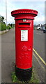
George V postbox on Park Road, Dundee
Postbox No. DD3 193.
See Image] for context.
Image: © JThomas
Taken: 11 Jun 2021
0.13 miles
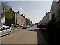
7
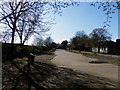
Site of former railway line
The pedestrianised area forms part of the former rail line between Fairmuir and Maryfield.
Image: © Douglas Nelson
Taken: 18 Apr 2015
0.17 miles
8
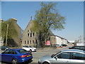
Former Fairmuir Parish Church
Now converted to dwelling houses. See also Image
Image: © Douglas Nelson
Taken: 10 May 2016
0.20 miles
9
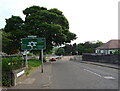
Old Glamis Road approaching the A90 roundabout
Image: © JThomas
Taken: 11 Jun 2021
0.24 miles