IMAGES TAKEN NEAR TO
Walkers Mill, DUNDEE, DD3 7DD
Introduction
This page details the photographs taken nearby to Walkers Mill, DD3 7DD by members of the Geograph project.
The Geograph project started in 2005 with the aim of publishing, organising and preserving representative images for every square kilometre of Great Britain, Ireland and the Isle of Man.

There are currently over 7.5m images from over14,400 individuals and you can help contribute to the project by visiting https://www.geograph.org.uk
Image Map
Images are licensed for reuse under creativecommons.org/licenses/by-sa/2.0
Notes
- Clicking on the map will re-center to the selected point.
- The higher the marker number, the further away the image location is from the centre of the postcode.
Image Listing (53 Images Found)
Images are licensed for reuse under creativecommons.org/licenses/by-sa/2.0
Image
Details
Distance
1
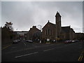
Coldside Parish Church, Dundee
Formerly Clepington Church, Coldside Parish Church was formed as a result of a union between Fairmuir and Clepington Churches.
Image: © Douglas Nelson
Taken: 28 Apr 2016
0.09 miles
2

Tannadice Street.
The football ground on the left of the picture is Tannadice Park home of Dundee United and the ground on the right is Dens Park home of Dundee F.C.
Image: © Paul McIlroy
Taken: 18 Nov 2005
0.09 miles
3

Allotments.
Arkley Street allotments with Tannadice Park in the background.
Image: © Paul McIlroy
Taken: 18 Nov 2005
0.09 miles
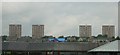
4
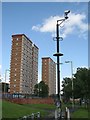
Tower block, Hilltown
View of two blocks from Ann Street. There has been some demolition of lower blocks of flats here.
Image: © Richard Webb
Taken: 21 Aug 2009
0.14 miles
5
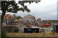
They are ex-flats...
Taken from a similar position to http://www.geograph.org.uk/photo/1455654. What happens when you send the demolition experts in..
Image: © Karen Vernon
Taken: 31 Jul 2011
0.14 miles
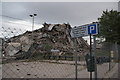
6
Pile of Flats!
The remains of one of the newly demolished Alexander St flats. http://www.bbc.co.uk/news/uk-scotland-tayside-central-14360053 Was there about 6 hours after the demolition and we were still noticeably breathing in the dust in the air. Amazing that such a large building makes such a small pile! See http://www.geograph.org.uk/photo/1626038 and http://www.geograph.org.uk/photo/1455654 to see what they looked like before
Image: © Karen Vernon
Taken: 31 Jul 2011
0.14 miles
7
Hilltown flats prior to demolition 31.07.11
Image: © jamesnicoll
Taken: 31 Jul 2011
0.14 miles
8
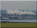
Hilltown flats demolished
The view from Gallow Hill near Gauldry, across the Tay Rail Bridge, to Dundee. The dust settles following the demolition of the Alexander Road tower blocks in Hilltown.
Image: © Jackie Proven
Taken: 31 Jul 2011
0.15 miles
9
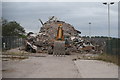
Any visitors?
May be a while until one is receiving visitors. The place is in a mess....
Image: © Karen Vernon
Taken: 31 Jul 2011
0.15 miles
10

Dens Road Market Dundee
Dens Road Market opened in 1969, there were more than 80 stalls and shops in the market, where you could buy almost anything. It boasted of being Dundee's Petticoat Lane. I spent a great deal of time at the market rummaging through the stalls looking for an priceless antique but if you weren't careful you were more than likely to come out with fleas.
Image: © Mary Rodgers
Taken: 27 Jan 2017
0.15 miles