IMAGES TAKEN NEAR TO
Infirmary Brae, DUNDEE, DD3 6QF
Introduction
This page details the photographs taken nearby to Infirmary Brae, DD3 6QF by members of the Geograph project.
The Geograph project started in 2005 with the aim of publishing, organising and preserving representative images for every square kilometre of Great Britain, Ireland and the Isle of Man.

There are currently over 7.5m images from over14,400 individuals and you can help contribute to the project by visiting https://www.geograph.org.uk
Image Map (Loading...)


Getting Data...Please wait
Leaflet Map data © OpenStreetMap
Images are licensed for reuse under creativecommons.org/licenses/by-sa/2.0
Notes
- Clicking on the map will re-center to the selected point.
- The higher the marker number, the further away the image location is from the centre of the postcode.
Image Listing (78 Images Found)
Images are licensed for reuse under creativecommons.org/licenses/by-sa/2.0
Image
Details
Distance
1
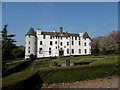
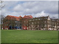
Former Dundee Royal Infirmary
The former DRI has been converted into flats.
Image: © Douglas Nelson
Taken: 25 Apr 2013
0.02 miles
2
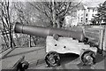
Time Cannon
The cannon overlooking Lochee Road was used for time keeping
up until the 1930’s. The ‘One o’clock gun’ was used by ships in the
harbour and the many citizens who did not own a watch. The cannon was reinstated in 2007 on the original platform overlooking Lochee Road. The old cannons were a great feature in Dudhope Park with children using them to play on.
Image: © Mary Rodgers
Taken: 3 Mar 2019
0.03 miles
4
Former Dundee Royal Infirmary
Now converted into flats.
Image: © Douglas Nelson
Taken: 25 Apr 2013
0.06 miles
5
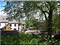
Housing on part of the former Royal Infirmary site
The Blood Transfusion and Laboratory Departments occupied this area for many years
Image: © Elliott Simpson
Taken: 12 May 2009
0.07 miles
6

Victorian Drinking Fountain
A neglected Victorian drinking fountain in the grounds of Dudhope Park.
Image: © Mary Rodgers
Taken: 3 Mar 2019
0.07 miles

8
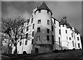
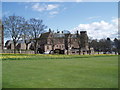
Dudhope Castle
Dudhope Castle was originally built in the late 13th Century as the home of the Scrymgeour family who were appointed as hereditary constables
of Dundee by William Wallace in 1298.
In 1683 the title and castle was conferred onto John ‘Bonnie Dundee’
Graham of Claverhouse, who went on to lead the Jacobites to victory
at Killiecrankie in 1689.
In 1792 there was an unsuccessful attempt to turn the castle into a
woollen mill. The Ordnance Office then had the lease of it for 95 years
as a barracks and storehouse.
My great uncle ran a boxing club in the castle during the years of the depression and after WWII to give young men an interest and keep them out of trouble.
Image: © Mary Rodgers
Taken: 3 Mar 2019
0.08 miles
9
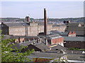
Inner city industrial area Dundee
This view is taken from the grounds of Dudhope castle looking south over the industrial inner city west of the city centre. Most of the buildings date from the jute 'era'. Today, former jute mills lie derelict, house small industrial enterprises or, as in the case of the large factory building on the left of the photograph, are converted into flats. The north of Fife is visible across the Tay (hidden) in the distance.
Image: © Val Vannet
Taken: 14 May 2005
0.08 miles