1
Constitution Road, Dundee
Extremely steep road in Dundee with a 14% gradient (1 in 7) - and I cycled up and down it.
Image: © Rossographer
Taken: 6 Jun 2022
0.01 miles
2
Glimpse of a villa
A fine Classical villa dating from ca. 1837 at the corner of Constitution Road and Union Terrace, which was once occupied by a jute magnate. B-listed: LB25506 http://portal.historicenvironment.scot/designation/LB25506 .
Image: © Bill Harrison
Taken: 9 Apr 2022
0.02 miles
3
Looking up Constitution Road, Dundee
The road is presumably one-way because of its steepness. The 'except for access' Laurel Bank curves away to the right and re-joins Constitution Road farther up the hill, having made a P-shape, with a number of fine Victorian villas along its length.
Image: © Bill Harrison
Taken: 9 Apr 2022
0.03 miles
4
New builds off Constitution Road, Dundee
Image: © Bill Harrison
Taken: 9 Apr 2022
0.05 miles
5
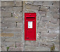
Postbox, Dundee
GR wall box (DD3 16D) on Constitution Road, Dundee.
Image: © Rossographer
Taken: 6 Jun 2022
0.05 miles
6
Almost at the top...
...of Constitution Road, Dundee. This is an interesting area to stroll around with Victorian villas side-by-side with gritty council flats. The pictured grime-stained villa with attractive Dutch gables dates from ca. 1851 and is B-listed: LB25161 http://portal.historicenvironment.scot/designation/LB25161 .
Image: © Bill Harrison
Taken: 9 Apr 2022
0.08 miles
7
Constitution Road, Dundee
Just north of the inner ring road, tenements with impressive chimneys...
Image: © Bill Harrison
Taken: 9 Apr 2022
0.10 miles
8
Elim Pentecostal Church, Dundee
In the right background is St Mary Magdalene's Scottish Episcopal Church. Note the nepus gables in the tenements in the background.
Image: © Bill Harrison
Taken: 9 Apr 2022
0.10 miles
9
St Mary Magdalene's Scottish Episcopal Church, Dundee
Built ca. 1867 for the Catholic Apostolic Church (https://en.wikipedia.org/wiki/Catholic_Apostolic_Church ) but the Dundee congregation disbanded in 1945 and the Episcopalians took over the building in 1952: B-listed (LB25113: http://portal.historicenvironment.scot/designation/LB25113 ). The inner ring road passes in front.
Image: © Bill Harrison
Taken: 9 Apr 2022
0.10 miles
10
St. Mary Magdalene's, Dundee
Image: © Dan
Taken: 6 Feb 2009
0.12 miles


