IMAGES TAKEN NEAR TO
Tealing, DUNDEE, DD3 0QZ
Introduction
This page details the photographs taken nearby to DD3 0QZ by members of the Geograph project.
The Geograph project started in 2005 with the aim of publishing, organising and preserving representative images for every square kilometre of Great Britain, Ireland and the Isle of Man.

There are currently over 7.5m images from over14,400 individuals and you can help contribute to the project by visiting https://www.geograph.org.uk
Image Map
Images are licensed for reuse under creativecommons.org/licenses/by-sa/2.0
Notes
- Clicking on the map will re-center to the selected point.
- The higher the marker number, the further away the image location is from the centre of the postcode.
Image Listing (11 Images Found)
Images are licensed for reuse under creativecommons.org/licenses/by-sa/2.0
Image
Details
Distance
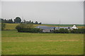
1
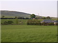
Newlandhead farm
Newlandhead is in the foreground with North Balluderon farm in the middle distance. The mast on the skyline is on gallow Hill (see NO 3940)
Image: © Val Vannet
Taken: 7 Jun 2005
0.10 miles
2
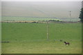
Fields at Newlandhead, Strathmartine
Image: © Mike Pennington
Taken: 19 Jul 2014
0.11 miles
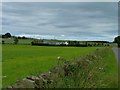
3
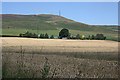
North Balluderon
This makes the farm look deceptively close to Craigowl (455 metres) in Image, but it neatly illustrates the transition from arable on the plain through pasture to moorland on the hill. The foreground crop is wheat.
Image: © Anne Burgess
Taken: 15 Aug 2010
0.12 miles
4
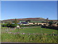
Newlandhead Farm
Farm viewed from the minor road passing on its south towards Auchterhouse. The masts beyond are on Craigowl Hill.
Image: © Stanley Howe
Taken: 8 Oct 2015
0.12 miles
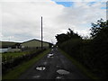

8
Newlandhead farm
Seen from the Auchterhouse to Tealing road.
Image: © James Allan
Taken: 9 Jul 2012
0.14 miles
9
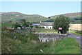
Newlandhead
The road turns sharply west for Auchterhouse, crossing the stone bridge in the foreground. The rather incongruous red sign reads, 'Newlandhead, Nt Balluderon'. On the left is Auchterhouse Hill, and on the right are the western slopes of Craigowl.
Image: © Anne Burgess
Taken: 15 Aug 2010
0.14 miles
10

Access to Newlandhead
From the minor road to Auchterhouse.
Image: © Stanley Howe
Taken: 8 Oct 2015
0.18 miles