IMAGES TAKEN NEAR TO
Strathmartine, DUNDEE, DD3 0PR
Introduction
This page details the photographs taken nearby to DD3 0PR by members of the Geograph project.
The Geograph project started in 2005 with the aim of publishing, organising and preserving representative images for every square kilometre of Great Britain, Ireland and the Isle of Man.

There are currently over 7.5m images from over14,400 individuals and you can help contribute to the project by visiting https://www.geograph.org.uk
Image Map
Images are licensed for reuse under creativecommons.org/licenses/by-sa/2.0
Notes
- Clicking on the map will re-center to the selected point.
- The higher the marker number, the further away the image location is from the centre of the postcode.
Image Listing (5 Images Found)
Images are licensed for reuse under creativecommons.org/licenses/by-sa/2.0
Image
Details
Distance
2
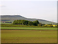
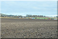
Craigowl from near South Fallaws
The summit of Craigowl (at 455m the highest point in the Sidlaws) dominates many of the grid squares to the north of Dundee. It forms the backdrop here to the farmland north of the minor road in the west of the grid box.
Image: © Val Vannet
Taken: 7 Jun 2005
0.09 miles